The small island of Madeira, only 57 km long and 22 km wide, is located in the Atlantic Ocean, about 1000 km from the continental Portugal, and 700 km from Morocco. With an average annual temperature of almost 200 C in Funchal – the capital of Madeira, it seems that the island has an “eternal spring” type of weather, at least for us!
After a beautiful hike in the stunning Newfoundland, and a few short trails in the Adirondacks, my appetite for hiking had just ignited throughout 2023. With over 200 Levadas (hiking trails following the water canals) plus 30 Veredas (mountain or coastal paths), Madeira’s hiking network totals over 2000 km of hiking trails, a paradise for nature lovers.

***
Pico Ruivo to Pico Areeiro
We finally got there. After 2 days of postponing, we managed to get on this famous trail. Our taxi driver dropped us off right in front of the trailhead and we were ready for a fresh start. After 50 metres or so, a large and noisy group passed by, heading in the same direction: Pico Ruivo. We let them pass in their haste; who wants to keep up with a loud group? Certainly not us. Walking on the main path made of small stones, surrounded by so many people gave me the feeling of being in a city park. I suddenly had a pungent feeling this is not what I was expecting. Will it be like this all the time, crowded and noisy? The day will tell..
PR 1.2 – Vereda do Pico Ruivo. We started the trail at a slow pace from Achada do Teixeira, and soon we realized that the constant incline and perhaps the altitude were not our best friends of the day. Soon we were gasping for more air, and we felt the crisp air straight into our lungs. We decided to go at a slower pace, as surely we had no reason to rush. Moreover, the sights began to delight our senses as soon as we spotted Santana on the northern edge of the island, the village where we were staying for four nights.
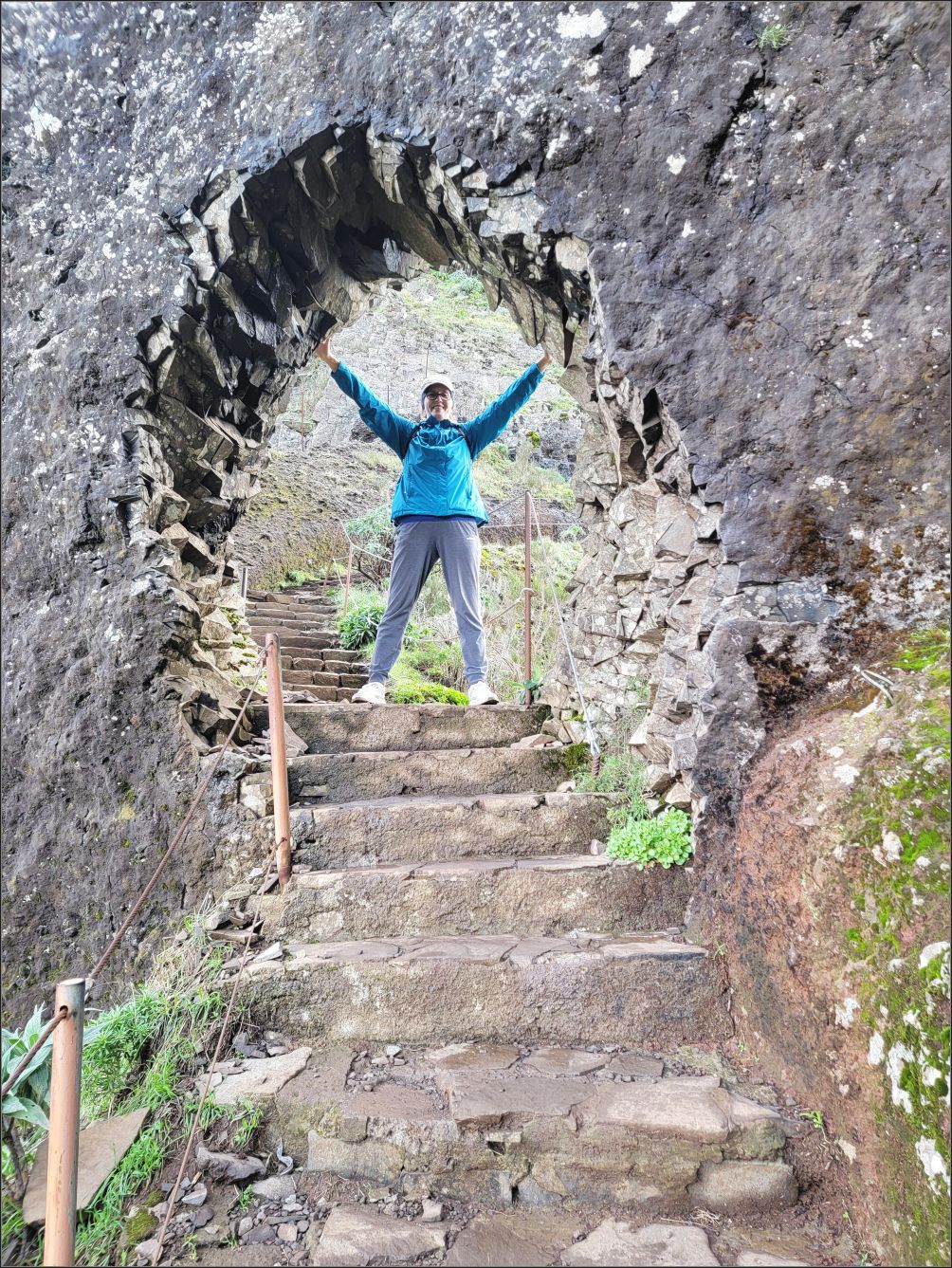
The trail looked so easy, with the rocky path winding ahead, but we soon realized the trail was anything but easy. At the first shelter on the way we met with the big group again, but we let them take advantage and go ahead, while we rested, enjoying the views.
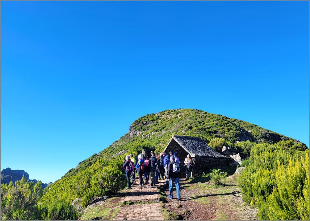
Cleverly located before the last leg of the hike, Casa de Abrigo do Pico Ruivo sits 500 metres before reaching the top, a nice resting area, offering a few drinks, and a washroom ($).

We suspected the last 500 metres would be more challenging, because of the steep slopes, but we were not prepared for the crisp air of the midday. We found it was quite difficult to breathe through the nose when we were huffing and puffing so much, but we eventually made it to the top, at Pico Ruivo! No one told us that in order to hike Pico Ruivo to Pico Areeiro, we had to hike the 2.8 km trail to reach the first peak, first.

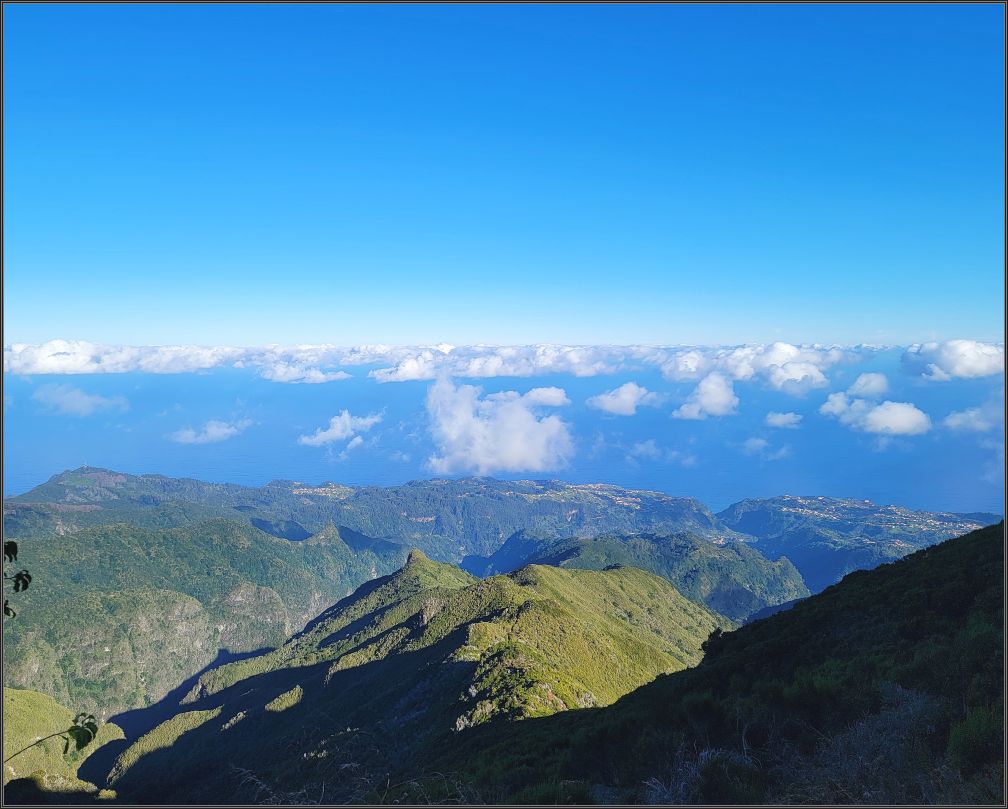
After few pictures at the lookout, we realized there was another viewing area northwest from the summit, where more people were sitting around, having their snacks, while indulging the panoramic views. At 1861 metres, the highest point of the archipelago Pico Ruivo did not disappoint!
At the junction signpost we had a little debate whether we should go ahead to Pico Areeiro, or go back. Although the hike is rated moderate, we realized that the cold air wouldn’t help. Speaking with a young (and well fit) German couple who confirmed that the trail is in fact difficult, didn’t encourage us. We finally agreed we should go ahead, since we already postponed this hike twice. The tactic was to go at a low speed, as slowly as possible.
PR 1 – Vereda do Areeiro is the trail connecting three iconic spots in Madeira, the highest peaks of the island. Covering part of the Central Mountain Massif (an area integrated in the Natura 2000 Network) this trail can be started from either Pico Areeiro, or from Pico Ruivo, and we chose the latter.
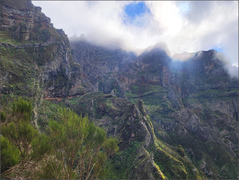
The trail started with a gentle descend, and after a sharp turn, we found ourselves passing by some dry and crooked trees, with obvious signs of being burned. It was such a curious sight, and a chill tingled our skin, as the thick mist of a foggy cloud enveloped us and the path we had to walk.

Fortunately, we crossed paths with several people going in the opposite direction, and as the trail narrowed quite a lot, we had to watch our steps more carefully, ignoring the strange feeling we had for a moment.
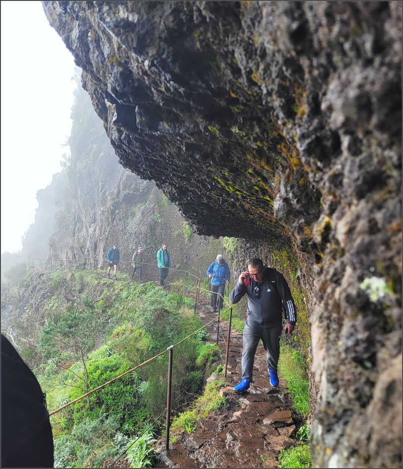
The path is very tight most of the time, and we had to let more and more people pass from the opposite direction. Sections are carved out of the rock to make room for a single track, and I often wondered how the trail handles the seasonal packs of tourists, if the off-season crowds were more than enough for these narrow paths.

However, we quickened our pace along the winding route, and our whole mood has lifted while a clearer sky replaced the low cloud. The scenery unfolding before our eyes was beautiful, and very different from what we were used to. Finally, my strong desire to hike a decent trail came true!
The trail provided spectacular views, and the cold air persisted along the way. Since we were going more downhill than up, we had no trouble keeping up a steady pace, although the hilly nature of this trail does offer a great workout for the adventurous ones.
As a person afraid of heights, I appreciated really quick how useful the rails were and kept looking at the ground most of the time. The trail is rocky, and interesting to observe how well maintained; each stone of these endless flights of stairs was like a piece of a huge puzzle of a unique path.
The first serious descend came up after half an hour of hiking or more, and after a quick glance at the gorge below, we kept watching our steps, as the next section was wet, not very good, and the stainless-steel rope was missing at some point. Luckily, there weren’t many people in this section, so we had our own tempo all the way down.

After another big turn, new mountains came to our view. We were right in the middle of the central mountain massif. We could see the path hanging like a serpent along the mountain ridge, just a small insignificant winding line among so many old scars of these ancient mountains. This was the point where we started observing the crust fissures induced by the submarine eruptions from millions of years ago.

We soon realized the path actually goes around the western side of Pico das Torres, as the eastern route was closed for the season. The path followed the shape of the mountain, and although feelings of vertigo tried me a couple of times, I kept moving.
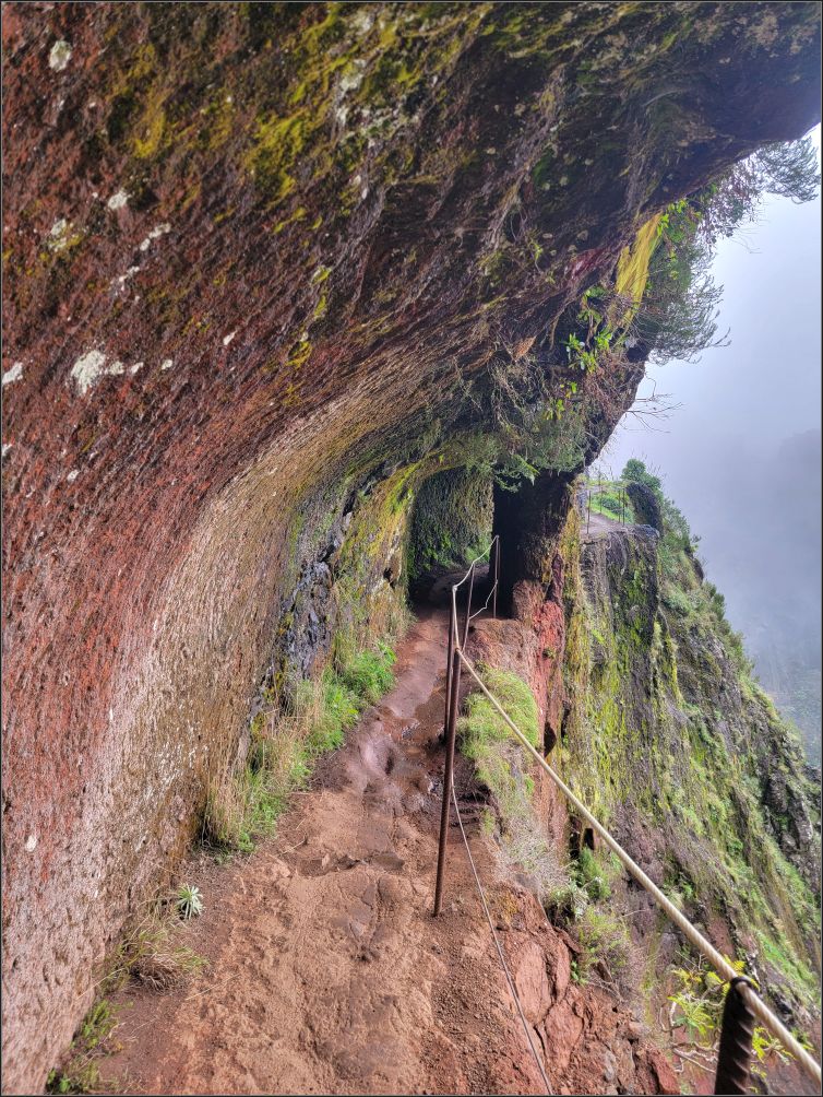
Several tunnels followed, and more walking of course. Interesting how much effort was put into making all these paths. We could only imagine how high or low the people were hanging over the cliffs, to be able to carve some of these paths, or to chisel out the tunnels of the tuff rock, in the middle of nowhere.
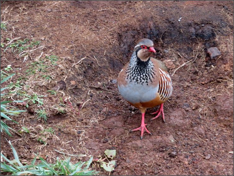
Some sections of the trails seem way too long, some others too difficult, but we kept entertained. Several red-legged partridges came our way. They seemed so used to people as they totally ignored us.
The mountain features were also offering us a lot of attention, as the surrounding clouds were constantly moving in and out. As we observed the sedimentary volcanic rocks layering with a dense basaltic stone, we thought this would be a true paradise for geology geeks.
But enough is enough, and the entertainment zone ended when we began our climbing. Several flights of stairs followed, and although they didn’t look menacing, the altitude had a tell. Huffing and puffing again, we started our ascent slowly but surely. Glad to take breaks so often, they weren’t a punishment, but actually a delight. So much to take in, and admire the views!
We kept walking: one step at a time. We felt tired. More tired. The stairs continued, on and on.

How many thousands of stairs, I wondered? I felt each and every step forward like a victory. Tired but relentless, we continued our journey.


After few turns and more stairs, we finally took a sight of Pico Areeiro summit. It seemed so close, yet so far away. Wonders of human kind, we noticed the carved path hanging along the edge of the mountain range. With only a stainless-steel rope between the mountain wall and the abyss, the path goes in a straight line for a while, to the final destination.

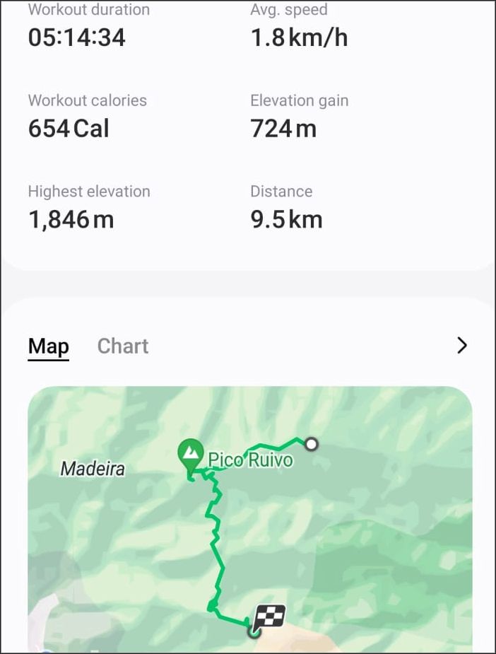
The Summit is near the white bubble we saw in the distance, which is actually the Air Defence Radar Station. After 6.7 km from Pico Ruivo, we reached our final destination. Pico Areeiro is the third peak in Madeira Island, with 1810m high. A very popular spot, at peak times, up to 1000 people a day can pass by the area.
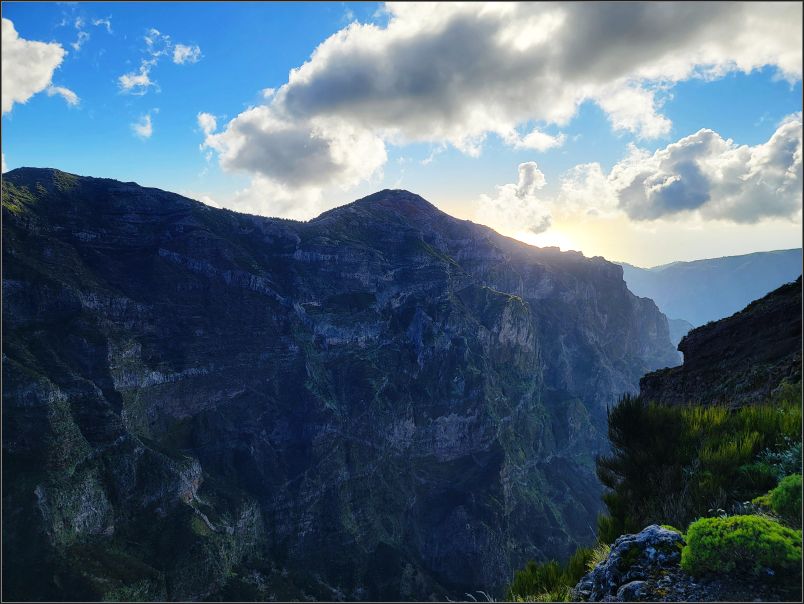
Finally! We took one more look behind, from the top, to bid goodbye to these bold mountains. The sun was caressing the top of them, and we finally enjoyed a respite, indulging a glorious day once again!
Tip(s) of the day:
- The trail can be done one-way starting from Achada do Teixeira to Pico Ruivo to Pico Areeira (as we did it), or viceversa. Or as an out and back trail starting and ending at Pico Areeira;
- The weather in Madeira can be very unpredictable, especially in the mountains. Wear layers, good hiking boots, eventually a hat. Water, snacks and a camera if desired;
- A headlamp, or any light would be handy while going through the tunnels;
- Check online for the trail condition and/or closures. It is closed as per official website as of right now;
- Although the trail might not be suitable for people suffering from vertigo, I felt very safe all the way along this trail. Stainless-steel ropes follow the trail, offering safety and security;
- There is no public transportation at neither of the start/end points. You can either take a guided tour, a transfer, or a taxi; or hitchhike;
- Pico to Pico hike 6.7 km one way – rated moderate, with an average of 3.5 hours, it was rather a difficult trail, with a bit of over 4 hours for us; Total hike 9.5 km from Achada do Teixeira to Pico Areeira took us almost 6 hours with all generous breaks included;
~ Visited in December 2023

An excellent place to hike. And it’s not every day that a person crosses paths with partridges.
LikeLiked by 1 person
Thank you Neil!
LikeLiked by 1 person
Gorgeous views all around! Madeira looks wonderful and it’s great you hiked all over!
LikeLiked by 1 person
Madeira is a little paradise, with so many hiking trails. We enjoyed it very much😊
LikeLiked by 1 person
Impressive path!
LikeLiked by 1 person
Thank you! I feel we’ve been so lucky, as the trail is closed as of now. Hopefully it will re-open soon!
LikeLiked by 1 person
Sounds like quite the challenge! But it looks like the hike was worth the effort as the views are stunning. Glad you had clear skies to soak it all in.
LikeLiked by 1 person
A hike without a little effort is not quite a hike, isn’t it?😀 We had great weather, and the rolling clouds in and out made it even more scenic.
LikeLiked by 1 person
It is on my list of holiday destinations to go hiking. Maybe one day. Your photos are gorgeous
LikeLiked by 1 person
Thank you Melodie! The whole island is gorgeous, you will love it!
LikeLiked by 1 person
Gorgeous scenery and wild trails, what a grand adventure!
LikeLiked by 1 person
It is amazing how much of Madeira forests are still wild, pristine lands. We really enjoyed being on these trails😊
LikeLiked by 1 person
Wow! I’m so glad you continued all the way to the top to share those views with us. I don’t think I’ve seen pictures of the mountains in Madeira before, it’s very beautiful! Maggie
LikeLiked by 1 person
These are one of a kind, man-made paths all around, in the middle of the wilderness. We didn’t know what to expect, but it was really interesting to see them!
Christie
LikeLiked by 1 person
Really beautiful! I have heard more and more lately about Madeira as a place to hike – might have to check it out someday!
LikeLiked by 2 people
It was a pleasant surprise for us too😊 I feel very fortunate to be able to hike this, end to end, as the trail is closed as of now, due to some landslides.
Have a wonderful weekend, and to more amazing hikes in 2024! Any plans for this year?
LikeLike
Quite a dramatic climb! The scenery is stunning.
LikeLiked by 1 person
Indeed, it was a hike of a kind, so glad we did it!
LikeLiked by 1 person
Fantastic that you did this, Christie. We spent a week on Madeira about 10 years ago but didn’t do any serious hiking. I’m impressed! The views are stunning.
LikeLiked by 1 person
I’m also glad we did it😊 A bit harder than what we expected, but it was rather in terms of the cold air we found in the mountains. The scenery is fantastic – like in the entire Madeira.
LikeLike
🤗🩵
LikeLiked by 1 person
Looks like a tough walk but with some spectacular views and sections! I’ve got my eye on a trip to Madeira at some point to walk the Levadas
LikeLiked by 1 person
Indeed, some sections were more difficult than others, but overall I’m so glad we did it. Beside the beautiful scenery, we had a great feeling of an accomplishment.
LikeLiked by 1 person