Kawartha Highlands Provincial Park (officially Kawartha Highlands Signature Site) is a 375-square-kilometre (145 sq mi) area of preserved wilderness used for recreational purposes in south-central Ontario, Canada. It is the largest park in southern Ontario after Algonquin Provincial Park, and is located North-East of the main belt of the Kawartha Lakes, in Peterborough County.
With an extensive network of lakes and rivers, this area also has historical significance as a trading route for Indigenous people and early settlers. Often called Canada’s Canoe Capital, The Kawarthas are known for many things. The name “Kawartha” derives from an Anishinaabe word meaning “land of reflections” or “bright waters and happy lands”. And here we are to explore these lands and enjoy the beautiful summer days.

A relatively new park, it became operational in May 2011, and permits for camping and parking are required since then. Campsites are designated and provided with picnic tables, fire rings and thunder boxes. Official Ontario Parks maps indicate the park’s boundaries and exclude small tracts of land containing pre-existing cottages.
If you are looking for a park where you can hike, this is not the park for you. The outdoor activities within this park range from backcountry canoeing and camping to a very short hike. Before visiting, keep in mind that the access points in the park have limited facilities and parking capacity. And you will need a map!
The park features many pristine lakes and wonderful views from various points of the forested areas or lakeside corners. You can test your fishing skills here or explore in a kayak or canoe. The landscapes in some areas are worthy of the Group of Seven (a group of Canadian landscape painters renowned for their distinctive style of painting the Canadian wilderness, particularly from Ontario) and contain wonderful trees, flowers, granite cliffs and sparkling lakes that are so famous in Northern Ontario. It is also a great place to photograph wildlife or spend time with nature.

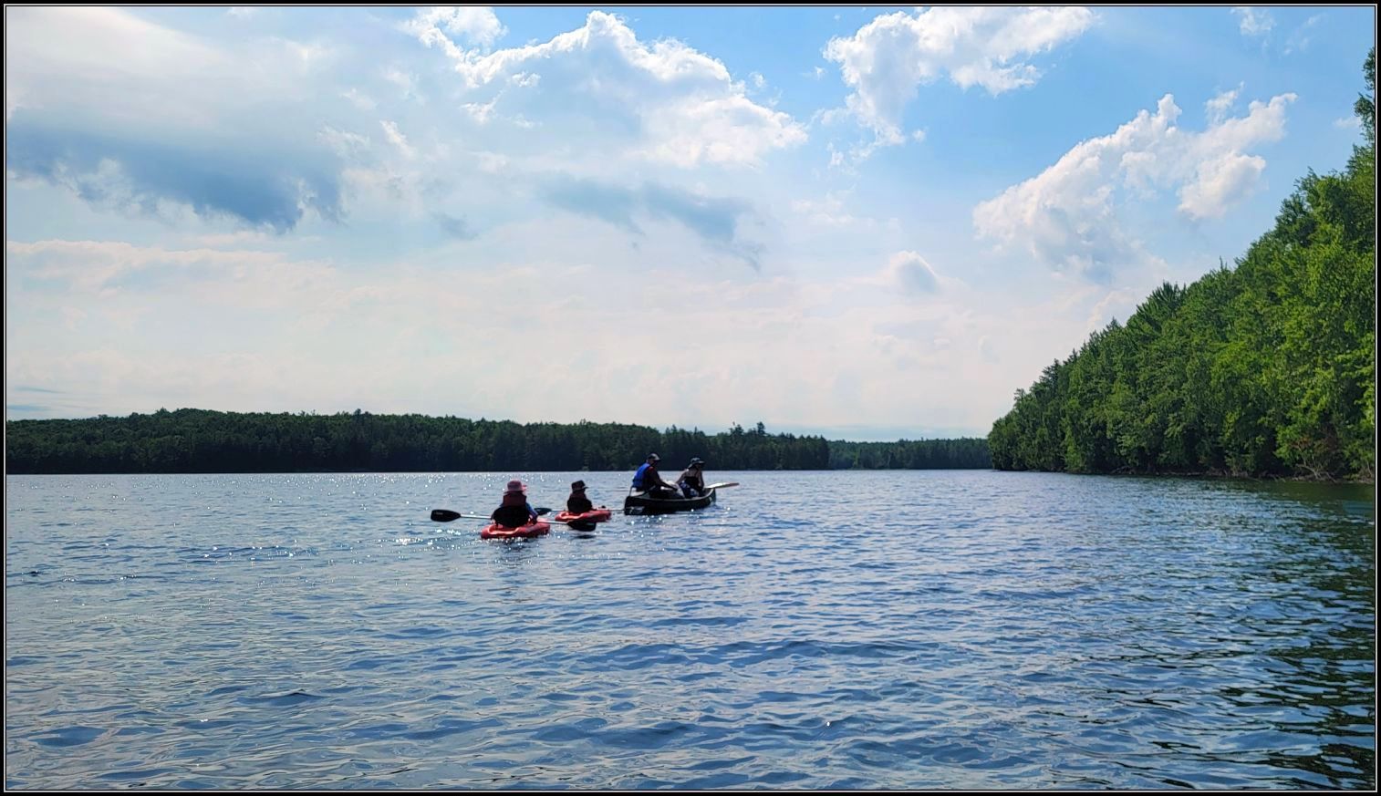
There are six recommended canoe routes throughout the park, ranging from easy to moderate in difficulty. We are by no means experts and we enjoy calm waters, preferring to take in the scenery and wildlife rather than paddling in moving or turbulent waters, or making long portages. So, we selected some easy sections of these routes, exploring some options for backcountry camping in case we change our mind in future.
Long Lake
Long Lake was our first choice at Kawartha Highlands PP. Fairly easy to paddle, this lake dotted with a few small islands is famous for its rocky shores and cliffs, where we hoped to see a different type of scenery.
The gloomy day didn’t dampen our spirits and we really enjoyed the first sight we had over the lake. The rocky shores covered with a dense layer of pine trees stood out against the dullness of both the sky and the water.

We started slowly on paddling and were very surprised to see so many people on the water. Judging by their gear, we assumed most of them were returning from camping.
Although the park doesn’t receive good reviews because of the cottagers along some of such lakes, we didn’t find them to be a nuisance as we only encountered two motorboats on our trip, and we kept paddling on a side, so we don’t get big wakes.
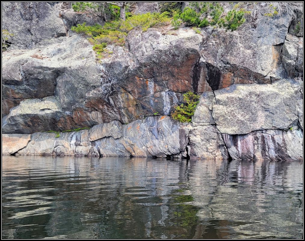
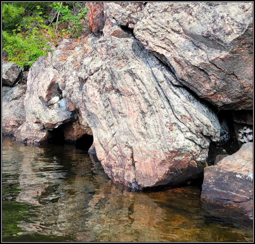
The scenery is beautiful on the right side, with towering granite cliffs and colorful rocks. Ontario’s landscape is famous for its Canadian Shield, and the Kawartha Highlands PP is located right along its southern edge. Originally very tall mountains over 4 billion years ago (since the Precambrian), the Canadian Shield has transformed into rolling hills today, after so many million of years of erosion. We found an interesting mix of landscape and various rock formations and structures along the entire ridge on the north side of the lake. The rugged terrain and exposed bedrock kept us entertained and we never got tired of admiring the shapes and the colours of the rock outcrops. If we knew how to read in stone, we could find an entire story, I’m sure.

We kept paddling, as our plan was to reach Loucks Lake, another smaller lake further on. But time was passing and it still seemed like a long way to go. I learned pretty quickly that our sit-on kayaks were not very fast, as many canoes were passing quite quickly. But we kept paddling and shortly we realize why this lake was named Long Lake: you get it too, right?😊
After an hour and a half of paddling we saw the first portage sign (towards Buzzard Lake) and decided it was time to return, as we still had a lot to reach Loucks and we didn’t want to stay until dak.


Three hours of paddling in total was quite enough for us, 9 km in total, out-and-back. We learned the pros and cons of our kayaks and concluded that it was a good choice to get them, as we definitely prefer safety and comfort over speed when talking about water crafts.
***
Bottle Lake
My first impression upon arriving at the parking lot was to see so many cars! It was completely wrong to think that this northern route might be too remote or unpopular. From the parking lot we started with a 218 m portage to the lake, and it only took us a few minutes to carry the kayaks to the water.
Historically known as Handsome Jack’s Lake, Bottle Lake was originally named after Jack Cow, an Indian chief who claimed all the streams and lands in this area as his fishing and hunting grounds. He was the most handsome man among the Chippewas, and many lakes and creeks in this area are named after him and his brother.
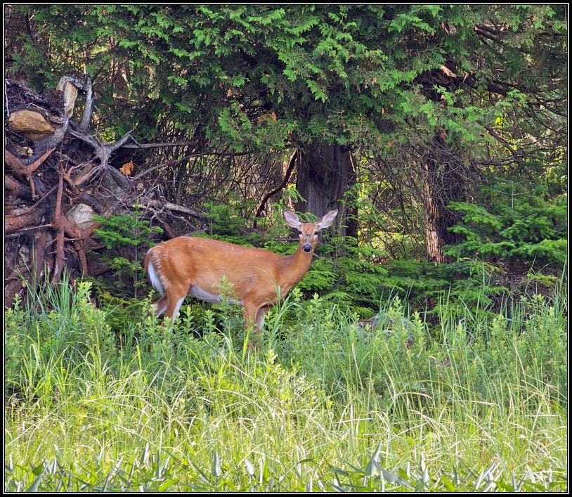
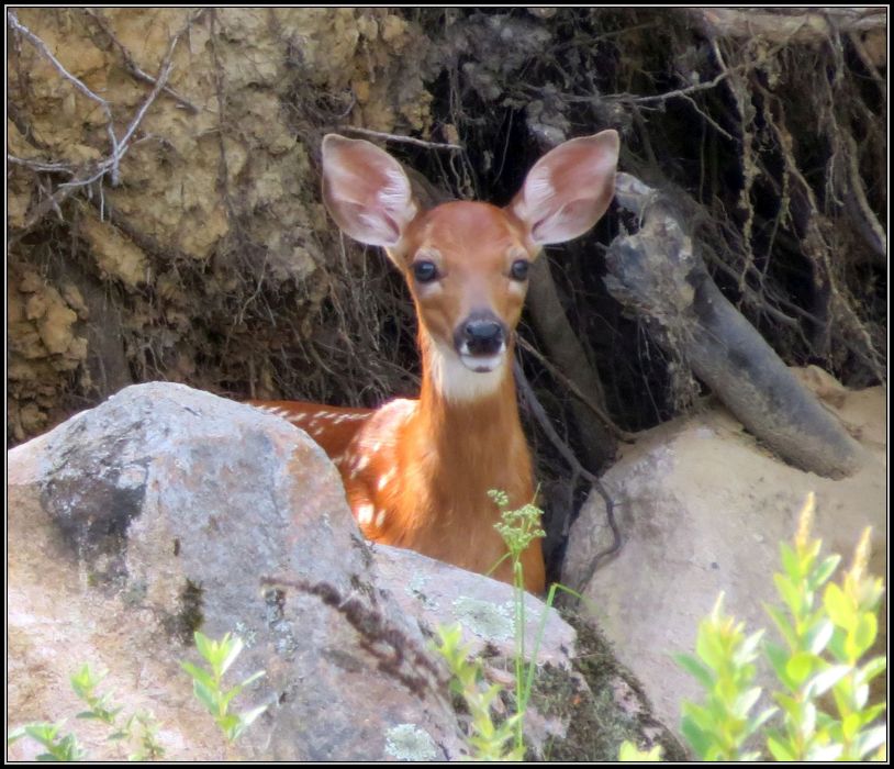
Shortly after we started paddling, we had a surprise spotting a doe and two fawns. Quite promising.
Pretty quiet on the lake, we only met a family returning from their camping adventure and asked them if the creek at the end of the lake is passable, where we planned to go to. We continued along the left bank until we reached the Creek. After almost an hour of paddling, I realized I hadn’t eaten my breakfast. Too much excitement😊
***
Stony Creek
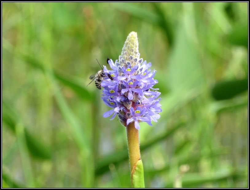
The mouth of the creek is large, with vast areas of blooming arrowheads. I decided we deserved a break and it was a good time to enjoy my breakfast in nature. A sandy beach stretches along the north and eastern shore, and although it seemed like a good spot to land and have the breakfast there, we didn’t want the extra paddling.

After gathering our strength, we continued. Birds accompanied us along the winding route; their loud songs was music to our ears. The sun was shining, making an enchanting setting. We tried to ignore the deer flies and hoped to get out untouched by these ruthless little creatures.
Paddling went quite nicely until we found a fallen tree across the channel when my husband jumped in the shallow water and pulled my kayak over the muddy section, so I wouldn’t need to do the same. So grateful to him!!

We soon reached the small cascade at the end of our route, but no sight of the mill ruins that was advertised on the map. We weren’t sure we have time enough to search for them, nor we wanted to be eaten alive by the deer flies; it was getting very hot, and we decided it was the time to turn back.

Two painted turtles, basking in the blazing sun, posed nicely before we reached the lake entrance, and we were glad to get there, as the breeze was a welcome bonus.

A windswept lake greeted us on the way back, and we had to push hard to get some speed. The doe was having lunch by that time, no sight of the fawns.

Paddling time was 3.5 hours, and about 8 km the entire trip back and forth.
Tip(s) of the day:
*If you want to do some backcountry camping, booking ahead of time might be a good idea, as the sites fill up easily several months before the season starts. For more information, you can read here.
*If you do not have your own canoe, there are several options for renting one, as well as camping gear. For trip planning, outfitters, accommodation & other services you can read more information here.
*Make sure you know well the topography in the park, as the park offers a diverse range of paddling options, from calm lake to white-waters.
*A canoe route map is available for sale from the park office, any outfitter, and/or online.
~ visited in June & July 2025

What a brilliant way to spend a day, Christie xx
LikeLiked by 1 person
Thank you!! xx
LikeLiked by 1 person
I canoed there years ago and visited again last year. Beautifully rugged country.
LikeLiked by 1 person
Never getting tired of this beautiful country🥰
LikeLiked by 1 person
I don’t know this part of Ontario, but I can see why it’s a paddling sports landscape. It looks beautiful and a great way to spwnd a few days in nature. Maggie
LikeLiked by 1 person
We moved in the “neighbourhood” two years ago, which is why we started exploring it more thoroughly.. it’s a wonderful area, and as you head north, you see more rugged and beautiful wilderness.
Hope all is well! xx
LikeLiked by 1 person
Looks like an amazing place. Love the title “Breakfast at Tiffany’s” .
LikeLiked by 1 person
Thank you😍
LikeLike
I love how beautiful the landscape is within the park, Christie, especially pristine lakes, rocky shores, and pine forests. Kawartha Highlands Provincial Park appears to be an ideal destination for those seeking an outdoor adventure in a stunning natural setting, offering numerous opportunities for exploration and recreation. Thanks for sharing, and have a good day 🙂 Aiva xx
LikeLiked by 1 person
Indeed, the park is quite large, and offers so many opportunities for further exploring. These were our first visits, and I’m sure not the last ones😍
Have a good one you too!! xx
LikeLiked by 1 person
🥰🥰🥰
LikeLiked by 1 person
Oh, ouch, deer flies! I wince. But the photos and the tale overall evoke only the best of memories. Thanks.
LikeLiked by 1 person
Deer flies were not part of the fun, but we managed to escape untouched😍
Thank you!!
LikeLiked by 1 person
We visited Kawartha Highlands for the first time a few years ago. It’s very different from Algonquin given all the cottages on some of the access points, but once you get deeper into the interior, it’s not so bad. The rocky cliffs along Lake Lake are beautiful; the deer flies not so much!
LikeLiked by 1 person
Indeed, Kawartha Highlands is totally different from Algonquin. We still have several routes to try, hopefully there aren’t many cottages in those areas.
Stay cool! xx
LikeLiked by 1 person