A visit to the Thunder Bay area along Lake Superior, Ontario, is not complete without a visit to The Sleeping Giant. We had the opportunity to see the giant’s profile from Marina Park back in 2021 and I have been thinking about it ever since. Famous primarily for one of the most iconic trails in Ontario, the Sleeping Giant was the main reason we returned here.
The Sleeping Giant Provincial Park
The Sibley Peninsula is a landform characterized by a series of mesas, jutting into Lake Superior, home to one of the most beautiful provincial parks in Ontario. Established in 1944, Sleeping Giant Provincial Park is famous for its 100+ km of trails, pristine wilderness, great wildlife viewing, excellent camping facilities and another local legend of Nanabijou (the Sleeping Giant). Native Ojibway oral tradition tells how Nanabijou, The Spirit of Deep Water, was turned into stone to protect a rich silver mine called Silver Islet. He was transformed into the giant landform when the secret location of the mine was revealed to white men.
We saw the giant’s profile a few years ago when we first visited Thunder Bay. From a distance, the Giant appears to be at rest. The stone figure sleeps peacefully on his back; arms folded across his chest and knees bent to one side. His mysterious presence has haunted me since our last visit, and finally the time has come to pay him a visit this year.

***
Top of the Giant
Although often referred to as the Sleeping Giant Trail, the hike to the Top of the Giant Lookout, Lake Superior Lookout and the Gorge combine several sections with varying levels of difficulty.
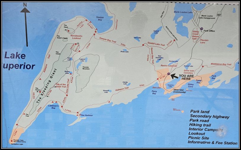
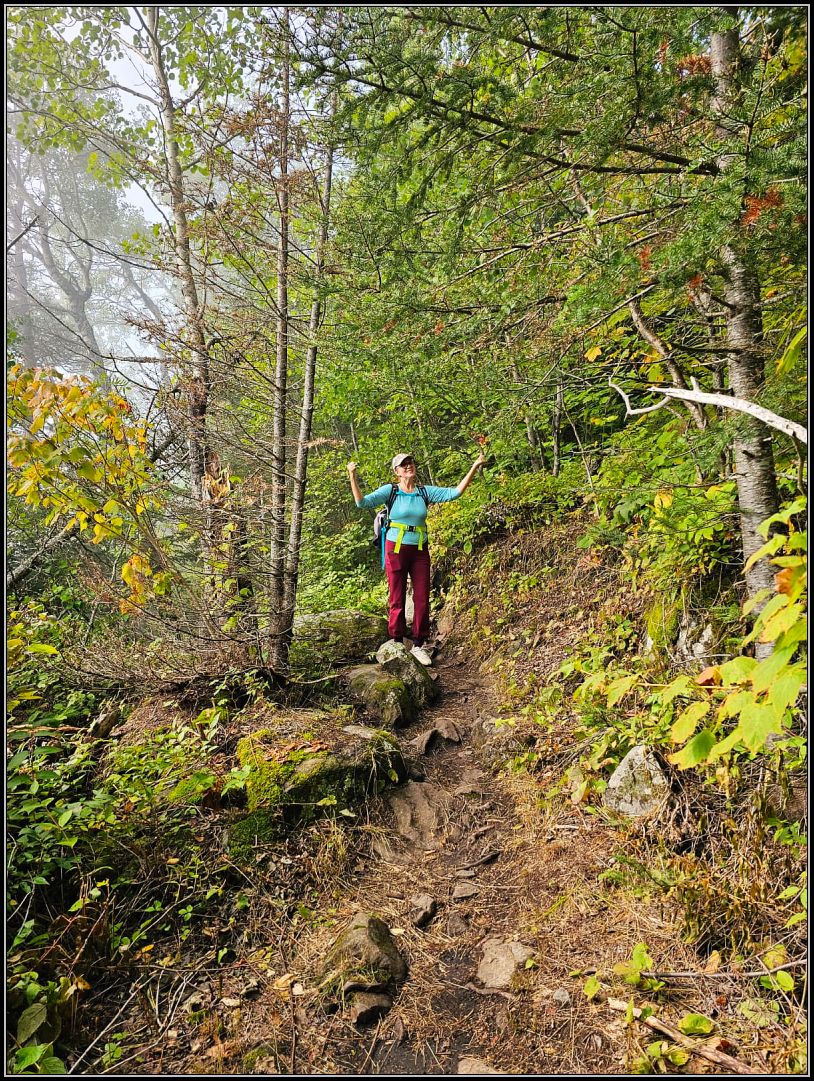
The trailhead is well-marked and starts from a large parking lot at the end of Highway 587. We found only 5 cars in the parking lot at 9 am, as the deceptive foggy weather has probably turned away many hikers that morning.
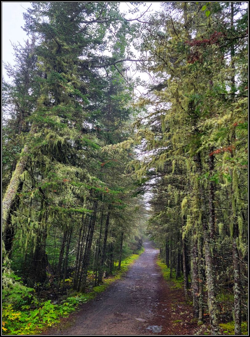
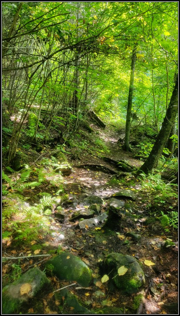
The trail starts at the southern trailhead of the Kabeyun Trail, with an easy 5.0 km trail that passes right by Tee Harbour. The path is wide, a kind of a “highway” to the Giant. Many people prefer to cycle this section, as this former logging road is quite straight. Except for the large potholes that took up almost the entire path in some sections, filled with rainwater from the previous night. Nothing really exciting. The dense fog was everywhere, sticking around the forest we passed through. But we enjoyed the nature and the Spanish moss hanging from the many trees along the way.

The actual hike began once we changed directions, towards the Talus Lake Trail. For about 1 km we started a moderate climb and were so glad to change the scenery. We quickly reached the next junction where the real climb begins.
As we progressed along the route, we saw more and more people. We enjoyed the foliage that was starting to change colours and the clusters of mushrooms that were poking their heads out after the recent rains.


My husband tells me at one point that once we climb the stairs, the trail gets much easier. I was just wondering what he meant, when I saw them, the giant stairs!


We wouldn’t have had any other option than to climb those muddy, steep slides if it wasn’t for the stairs. So, we climbed them! Step by step, feeling like in the giant’s shoes, I wondered if these huge steps were really built after the giant’s feet. While not being overly technical, this section was very demanding, physically speaking. I felt really victorious reaching each milestone and quickly found the bench and the signpost showing us the distance left to go. I knew the path would be easy from now on.
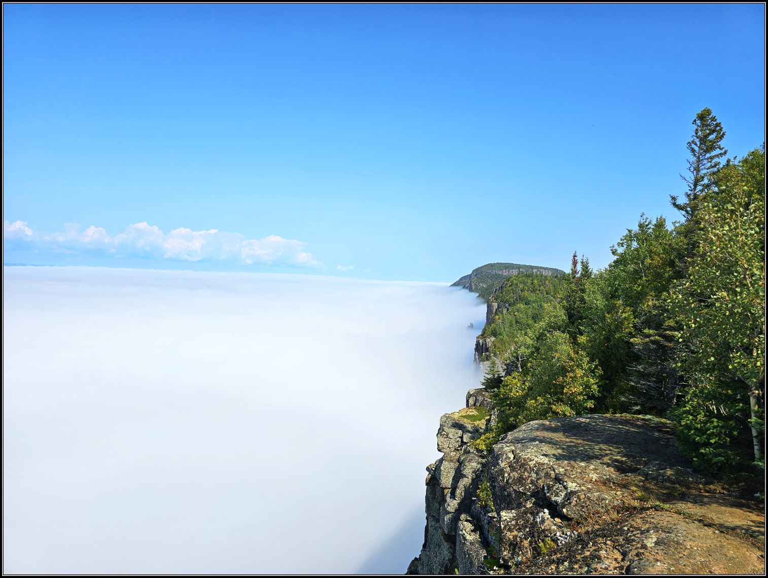
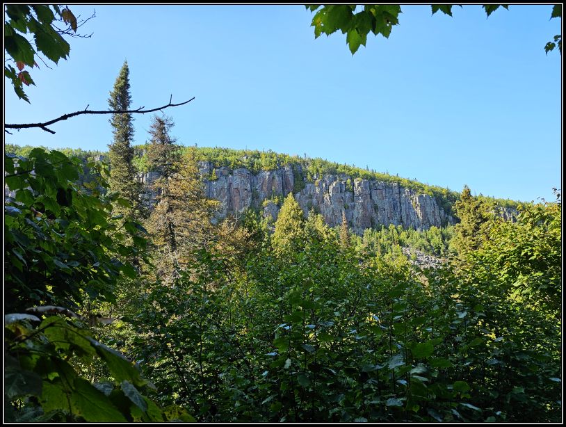
The rest of the trail winds for awhile to the top of the Giant, and we were quite disappointed to find ourselves above the clouds. Proud to have reached the top, but somewhat disappointed that the fog hadn’t cleared, we continued our way to the Lookout, where we had planned to take a break.
At 290 metres, the top of the Giant is not the highest point in Ontario, but it is one of the most sought-after hiking destinations in the province. We found a good cell service reception at this point and took a long, well-deserved break, soaking in the sun while we ate lunch.
The sun was shining above the thick layer of the clouds, making it impossible for us to see Lake Superior. It is said that the sky and water are a seamless hue of bright blue – unfortunately, we could only imagine what it would be like on a sunny day. And yet, there it was the top of the Giant, in full size, resting atop of the sky – we could see its profile, almost touching it.
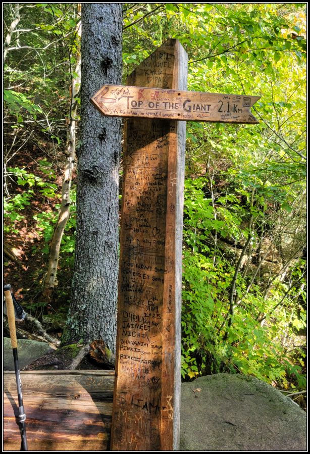
Several maps show the one-way distance to the top as 11.9 km, which we reached at this point. We didn’t see any sign around and weren’t sure if the trail follows to The Knees or the big loop of the Kabeyun Trail. After walking a little further, we found a sign showing us we have another 0.9 km to reach the Gorge. Once there, we decided to return quickly, as the fog wouldn’t lift for another 3 hours.

***
Talus Lake Trail and Sawyer Bay Trail
We were already toying with the idea of returning to the parking lot on a different route. The first five km of this trail wasn’t our favourite part and we thought we can try something else.
The trail system combines several trails, and the connection between Top of the Giant, Talus Lake and Sawyer Bay trails would be a perfect loop for us. The fog seemed to have cleared after all and the sun was starting to shine, so the extra 3 km of hiking didn’t seem too long. We soon parted ways with our hiking buddy we met on the way and changed direction at the Talus Lake Junction.
As soon as we set off on the new trail, we noticed the change. The easy path, the solitude and the lack of crowds were a real joy and we were so glad we made this decision. After 2 km we slowed down, enjoying the birdsong and the welcoming meadows. We even got startled by a hummingbird! I thought they had gone south by this time, as they really have to go a long way to their wintering grounds.

The path narrowed and I noticed that it was much less traveled, but we continued. Soon a steady climb began and I found myself in front of boulders I could no longer climb. I kept looking for a way to continue, but I couldn’t see any solution. I knew that my husband was waiting for me to move forward, but I didn’t know what to do.
After searching for ways to climb or go around the large boulders and the steep slope over and over again, I decided it was time to go back. Hard to accept, I turned my head and told my husband that it was a bad decision to choose this route and that we better return before it was too late. But then I looked back and realized that I couldn’t turn back either. Unless I let myself slide down the muddy slope!
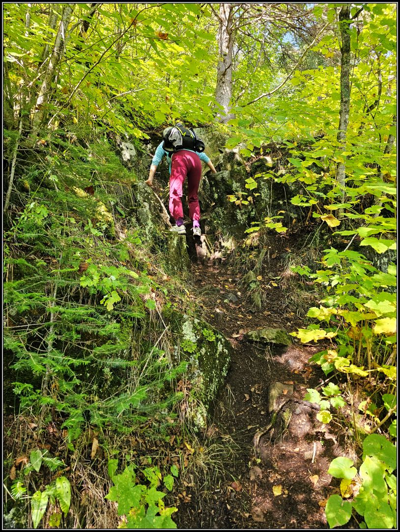
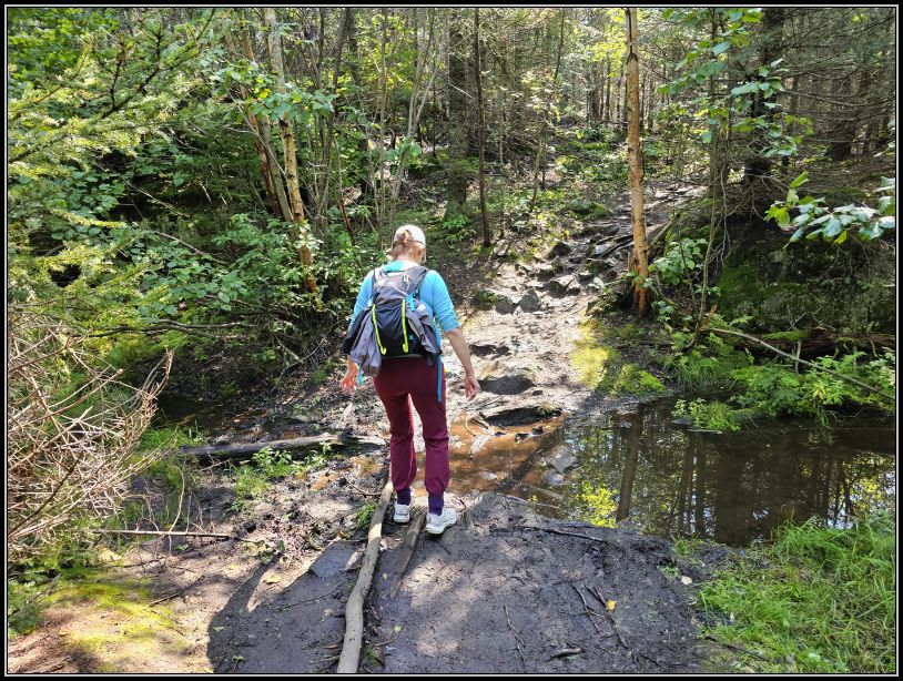
This was the time when my husband came to my rescue and, hand in hand, we found the way. Without looking back, we made it through the great impasse quite well and breathed a big sigh of relief when we found ourselves on a solid and clean trail again. We knew that Lake Norma was around the corner, or at least pretty close. Luckily the trail is well marked, giving us reassurance that we were on the right track.

We soon found Lake Norma, an oasis of peace in the middle of the wilderness. This delightful expanse of water is set in its own carved bowl surrounded by the towering cliffs. The sky was bright and sunny, the perfect time to enjoy the nature. It was a good decision to take this path after all!
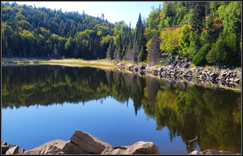
I was so glad that this part of the park is not so touristy and we found a moment of solitude and quiet contemplation, grateful to Mother Nature and all that we have. And especially we have each other.
Fallen trees, jagged rocks and treacherous roots are common in the wilderness, nothing really special followed, except the wonderful feeling to be free in the woods again.
After a while we saw Lake Talus. The bright reflections of the pines perching high on the back of the Giant kept us entertained, and that was when we saw the first people on this trail since we split from the main trail.

After a brief stop, we continued our way. We expected throngs of people, or at least some of them, but the trail was surprisingly quiet. We got to the Sleeping Giant after all, one of the most sought-after parks in Northern Ontario. But this trail was empty and I was so happy that we were finally able to hike one of the most beautiful trails we have done this year, and in fact, in all of Ontario.
After meandering through the picturesque surroundings, with more ups and downs, we began the descend. Soon we reached Talus Creek, which we followed for about 1 km. A wonderful piece of walk in the middle of the forest, with the little cascades whispering to us. Shortly we had the option to continue to Sawyer Bay, but it was getting late and we still had 6 km to the parking lot, so we said next time.
Little did we know about the (last) 6 km of forest road weaving through the woodland. This stretch was not difficult in itself, but the lengthy walk we’ve had since morning didn’t go unnoticed by our legs and knees. And not to mention how happy our toes were when we finally arrived at the parking lot!

Tip(s) of the day:
*Top of the Giant and the Lookout are located at the top of the mountain and have absolutely no railings or protection. Exercise extra caution when you reach the top;
* Top of the Giant can be very crowded at times, so be prepared to give other hikers space in the narrow sections of the trail;
*All trails are out-and-back, but if you prefer to do a longer trail that connects 3 trails in one big loop, you can link Kabeyun, Talus Lake and Sawyer Bay trails, as we did; Top of the Giant trail itself is rated difficult and increasing the distance can increase the difficulty, so be prepared if taking such decisions; it took us 10 hours in total;
*The weather can change at any time, it is quite unpredictable; be prepared with extra layers of clothing, a rain jacket, snacks, water, a flashlight and sturdy hiking shoes;
*you are in the bear country, so be prepared for any kind of wildlife.


~visited in September 2025
If you like hiking and looking for more ideas, here are few places you might like in northern Ontario:
Our favourite day trips from Thunder Bay

Love these views!
LikeLiked by 1 person
Thank you!!
LikeLiked by 1 person
I’ve been through Thunder bay. It was a life time ago.
LikeLike
Such a beautiful park, wow!!! ❤️🇨🇦
LikeLiked by 1 person
Thank you, John! xx
LikeLiked by 1 person
You’re welcome. ☺️
LikeLiked by 1 person
We travelled through that area 18 months ago. Very beautiful.
LikeLiked by 1 person
Thank you, Lynette!!
LikeLiked by 1 person
Oh my gosh, I can see why Top of the Giant is so popular! I love the photos of the cliffs and being above the clouds.
LikeLiked by 1 person
Indeed, the fog and the clouds gave an interesting appearance to the Giant and the surroundings🥰
xoxo
LikeLiked by 1 person
What a great park. And you saw a whole lot of it.
LikeLiked by 1 person
Thank you! We did take quite a long route..
LikeLiked by 1 person
Wonderful
LikeLiked by 1 person
Thank you!
LikeLiked by 1 person
You do like a bit of adventure! Once you start to climb it doesn’t look easy underfoot but, as you say, thank heaven for our partners. Mine regularly has to haul me up xx
LikeLiked by 1 person
Thanks God we have them🥰
xx
LikeLiked by 1 person
I did this hike many years ago and have forgotten most of it. I know you wanted a clear sky, but the views of the Giant above the clouds is a great picture. Maggie
LikeLiked by 2 people
Indeed, we still had an amazing view from the top! Overall it was a great day, having so much fun.
xoxo
LikeLiked by 1 person
Quite the trip, Christie, obviously beautiful, but not without challenges. I can almost hear your sigh of relief when you got back to your car. As for those giant steps I’m reminded of many steps in the Sierras of California that were made for horses instead of people.
LikeLiked by 1 person
Hmm.. you made me curious now, I’m sure Sierra Nevada mountains stand out in many ways from all those beautiful mountain ranges along the west coast.
Have a lovely week ahead!
LikeLike
There are several ranges, but most of them fit into either the Sierras (basically fault block raised) and the Cascades (Volcano based.) Thanks. It was a great week.
LikeLiked by 1 person
I commend you both for undertaking such a challenging hike, Christie! Our days of hiking trails half as hard are way over, but I enjoyed reading about yours. Like others wrote, the image of The Sleeping Giant above the clouds was superb! Thanks for showing me another part of my native Ontario. No wonder its motto is (was?) “Yours to Discover.”
LikeLiked by 1 person
I also love the quote “Yours to Discover”, it is truly fitting to this beautiful province. So large and so much to discover🥰
LikeLiked by 1 person
Adventuresome and scenic, and I loved the fox at the end!
LikeLiked by 1 person
Thank you Lexie, we’ve had quite an adventure. No bear sighting though.. although I’m never sure if I really want to see one on the trails😀
LikeLiked by 1 person
What a beautiful hike, and a gorgeous shot of Lake Norma. Such a lovely spot!
LikeLiked by 1 person
Thank you so much, Helen, for your lovely comment. And for coming along💛
LikeLike
I’m such a fan of Sleeping Giant. The Top of the Giant is one of my favourite trails in Ontario. It’s too bad about the fog, but your pictures are still really neat. And at least it wasn’t raining! I like how you took a different route back to the parking lot. Lake Norma looks lovely.
LikeLiked by 1 person
Indeed Lake Norma was a little oasis of peace where we recharged our batteries. There were also some campsites nearby, but we didn’t see anyone around.
Now, it’s also one of our favourite trails in Ontario, too🥰
LikeLiked by 1 person
We drove and camped over the tops of the Great Lakes years ago. I wish I had known of this park. It looks like a great place to explore. The photo of the white cloud cover is stunning!
LikeLiked by 1 person
Thank you! Indeed, that park is so beautiful, one of our favourite hikes in Ontario🥰
LikeLiked by 1 person