
Located in the municipality of Santana, on the northern coast of the island of Madeira, the Queimadas Forest park is one of the best places to observe Laurissilva Forest. Home to the typical flora of Madeira’s Laurissilva Forest, we found this park very peaceful, especially PR 9 – Levada do Caldeirao Verde the perfect place to have a relaxing walk, and admire nature, especially after a demanding hike on the previous day, Pico to Pico.

Starting from Casa de Abrigo das Queimadas, Levada do Caldeirao Verde shortly follow an exotic path. After passing a couple of ponds with some interesting ducks, the path took us right to the middle of the Laurissilva forest. A coupe of gigantic trees greeted us along the way, before the large path narrows, leaving room for a one-way track in most places.

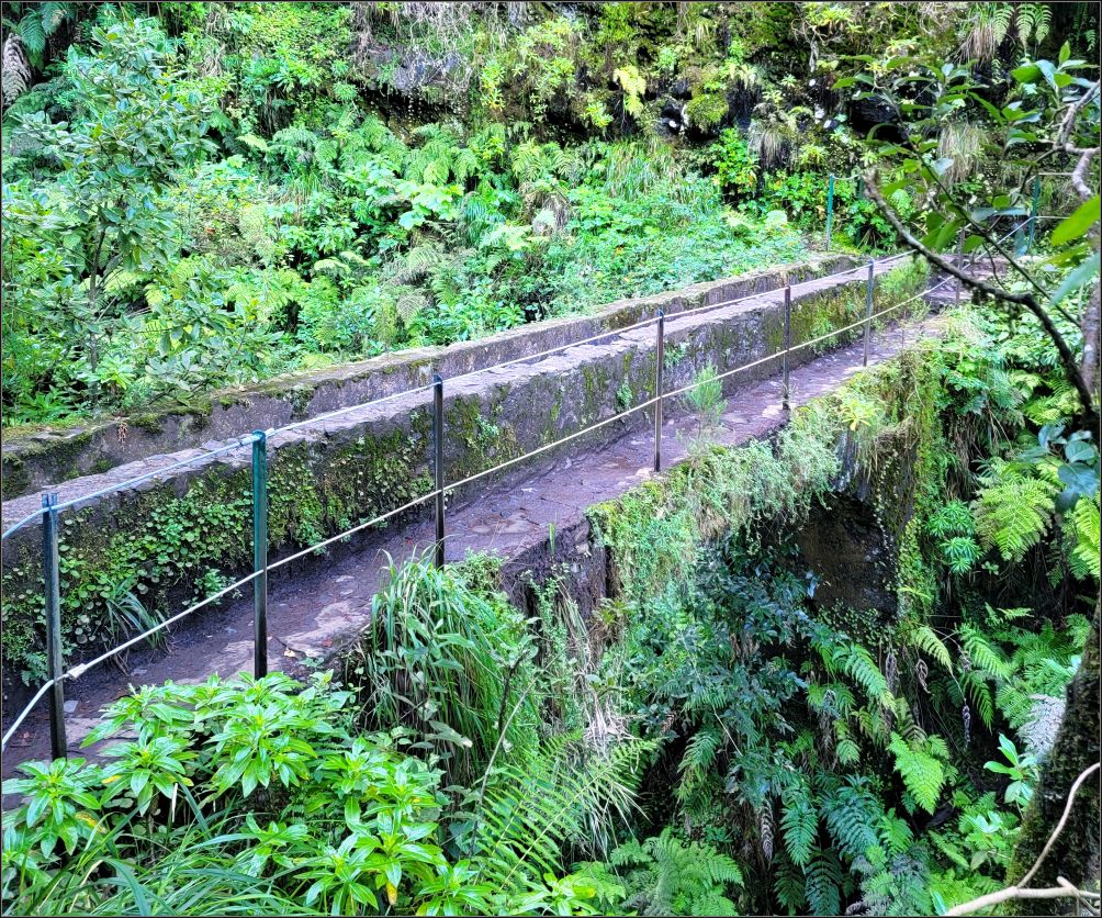
Except for the first post sign we passed by at the beginning of the trail, there is no marking. But nothing to worry about, you can’t really take any other route (except PR 1.1 which is very well marked). The path simply follows the ‘levada’, the water channel built in the 18th century, which carries water to the farmlands of the parish of Faial. An easy walk, as the trail goes fairly flat. This is the time to admire the escarpment and the mountains, as well as the rich vegetation of the Laurissilva forest.
But what is this Laurissilva Forest about?
Try to imagine a widespread forest that covered much of Southern Europe more than 15 million years ago. A subtropical forest, found in areas with humidity, and relatively stable, mild temperatures. The forest is characterized by broadleaf tree species with evergreen, glossy and elongated leaves known as “lauroid”.

But the laurel forest is no longer as wide as it was, as it’s practically extinct today. It is still found in the islands of Macaronesia in the eastern Atlantic (among other parts of the globe), in particular the Azores, Madeira islands, and Canary Islands. Due to its size, and quality, the laurel forest of Madeira is the largest survival area (approximatively 15,000 hectares), and is believed to be 90% primordial forest. Reason it was declared a UNESCO World Heritage Site since 1999.
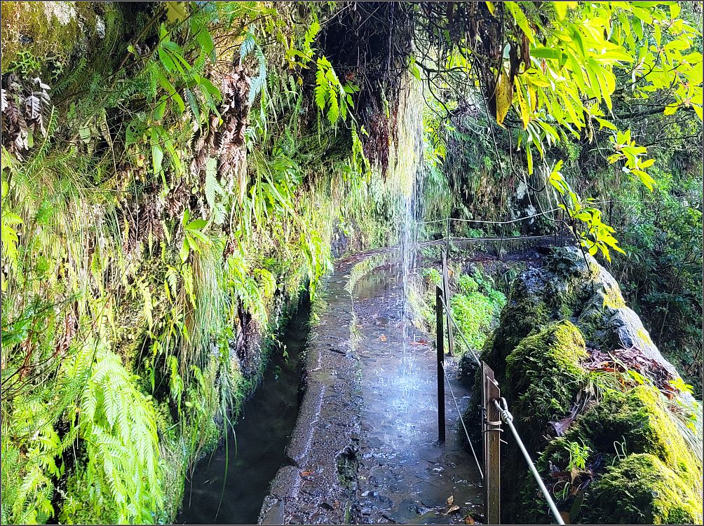
Rated as a trail of moderate difficulty, this 6.5 km long Levada do Caldeirao Verde took us along some of the greenest parts of the mountains we saw on the island. The landscape became livelier from time to time, complemented by the streams of water that fell down with sumptuous elegance from above, making impromptu waterfalls we had to walk underneath sometimes.
The path is mostly flat and shaded, and it winds up the curves of the mountain, following the water channel. We rarely intersected with other hikers, which made the hike much more pleasant.

Although some sections are really narrow, they are always protected with a stainless-steel side rail. The deep valley along our path revealed occasionally expanding vistas of the surrounding mountains. Still, we had to watch carefully our steps, and be alert, despite the sense of safety we felt behind the steel rope.

We were once again in awe of the lush vegetation, especially the long grass watered heavily by these abundant streams of water falling down from the sky. It’s no wonder why the early settlers came up with this idea, to build these canals and carry the water from the mountains all the way to the agricultural fields along the coasts.
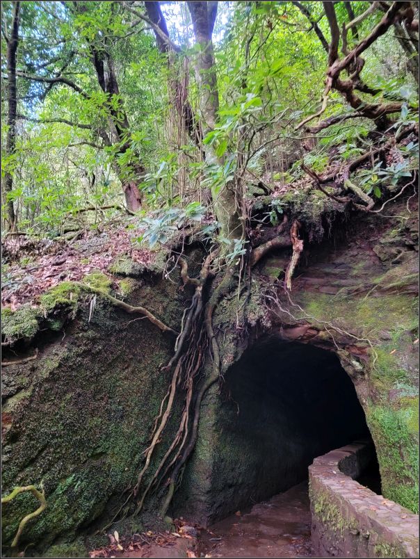
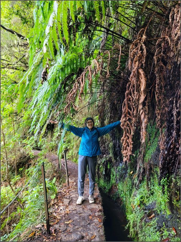
We passed by several tunnels of various length. Watching the low ceilings while looking at the steps became an interesting way to go in the tunnels, especially when we crossed paths with other people. But the fun continued, enjoying the rich vegetation, especially the 2 metres long ferns, and several other waterfalls.

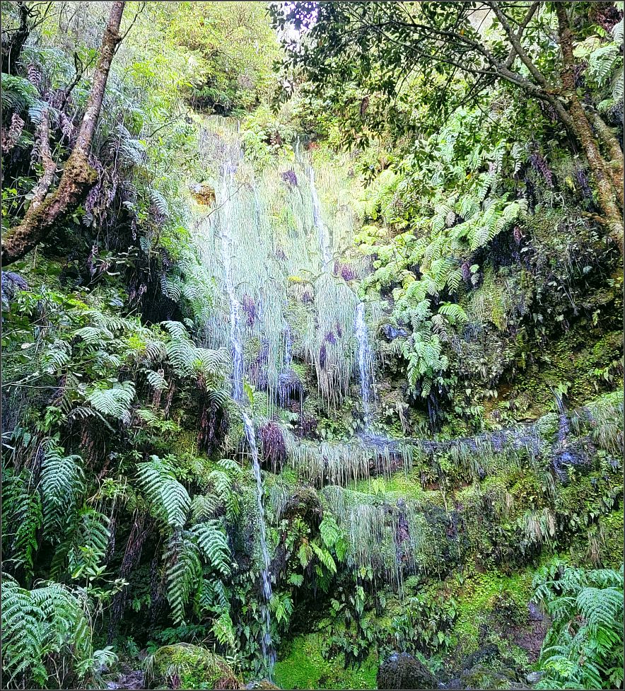
Eventually we reached the end of our trail, finding the small Caldeirao Verde lake. After a quick stop and a photo session in front of the waterfall which drops vertically from the brook Ribeiro do Caldeirao Verde for about 100m, we took a well-deserved break, taking in the energy, while enjoying the flora and fauna of this area.


We didn’t feel like going further ahead to Caldeirao do Inferno (2.2 km further away), so retraced our steps back, returning on the same way back to the parking lot.
Tip(s) of the day:
- Starting from Casa de Abrigo das Queimadas, Levada do Caldeirao Verde is 6.5 km long (13 km round trip) and is rated moderate due to the distance. It took us almost 5 hours in total with lots of breaks along the way;
- The weather in Madeira can be very unpredictable, especially in the mountains. Wear layers, good hiking boots, eventually a hat. I found it quite humid in this type of forest;
- A headlamp, or any light would be handy while going through the tunnels;
- Check the official website for the trail condition and/or closures;
- Although the trail might not be suitable for people suffering from vertigo, I felt very safe all the way along this trail. Stainless-steel ropes follow the trail where needed, offering safety and security;
- There is no public transportation to this park. You can either take a guided tour, a transfer, or a taxi; or hitchhike.
~ Visited in December 2023

I would’ve never guessed this was on Madeira, but rather somewhere in England or New Zealand! Such lush greenery all around. Will have to make it over to Madeira some day!
LikeLiked by 1 person
I totally agree! My idea was it could easily be England or the Black Forest in Germany.
LikeLiked by 1 person
2 places I have yet to visit🙂
Thanks for reading and sharing your thoughts, have a lovely day!
LikeLike
Thank you for your nice comment, Rebecca! I can’t really compare Madeira with these countries, as I have yet to visit them🙂
Madeira is famous for its four separate microclimates, despite its (small) size. It is surprising how different the weather and the vegetation can be on different points of the island.
Happy Tuesday🙂
LikeLiked by 1 person
Christie you visited there Madeira with these Waterfalls. Such an amazing site. Anita
LikeLiked by 1 person
Amazing place, indeed!
LikeLike
Very beautiful. I hadn’t heard of this island before. Thanks for writing about it.
LikeLiked by 1 person
I also heard about Madeira from other bloggers🙂
LikeLiked by 1 person
Thanks for introducing me to a place I didn’t know.
LikeLiked by 1 person
You’re most welcome!
LikeLiked by 1 person
What a beautiful spot to go for a hike and enjoy the scenery. Everything looks so lush. And how cool to walk underneath the little waterfalls. The big waterfalls are pretty impressive too of course.
LikeLiked by 1 person
There are quite few impressive hikes on this little island of Madeira. And so many waterfalls!!
Have a lovely day Linda, it seems the weather is getting better these days🙂
LikeLiked by 1 person
I remember walking through similar laurissilver forests on the island of La Gomera a few years back. They are, as you’ve so rightly said, fascinating places full of wildlife and interest.
LikeLiked by 1 person
Canary Islands are on our list😍 Which island would you think is the best in terms of similar scenery, besides La Gomera?
LikeLiked by 1 person
La Gomera is undoubtedly the best, it has far more uninhabited areas than the others (although we haven’t visited all of them. La Palma has some very attractive scenery too but for us La Gomera stands out.
LikeLiked by 1 person
This is so pretty! I’ve never heard of a laurel forest before, but I’m glad this one still exists. It’s so lush and green!
LikeLiked by 1 person
So glad we were able to get an amazing weather while in Madeira. The scenery is fantastic🙂
LikeLike
I have a good friend who has hiked there, so I knew about it in theory. She was freaked out by the steep exposures. Your photos really bring it to life … I’d love to go!
LikeLiked by 1 person
There are few steep exposures indeed, but I felt very safe all the time (due to the cable fences along those trails) despite my fear of heights🙂
Happy Friday!
LikeLiked by 1 person
surprised that you might need layers thought it would be hot most of the year, but I had no idea that such a tropically dense island existed so close to Europe and North Africa. thanks for sharing it looks simply amazing
LikeLiked by 1 person
Surprising for us too, as there are actually 4 microclimates in such a small island. Although we had to put layers while we were in the mountains (we’ve seen actually some ice while hiking Pico to Pico), next day we had to put our shorts while hiking the Dragon’s Tail (to come soon🙂)
LikeLike
I looked at the entrance to the cave Christie and I immediately wondered if you were traveling with a head lamp. Other than that, it looks like a delightful hike. Thanks for taking us along.
LikeLiked by 1 person
We only had a flashlight, which was pretty ok. But I still had a mishap in one of the mud puddles inside (if you noticed, one of my shoes had a darker colour😜), while I was letting other people pass through the narrow tunnel. It was part of the fun😍
LikeLike
Alls well that ends well, Christie. 😁 A flashlight was just fine. Having to slip by people in a narrow tunnel reminds me of exploring under thew pyramids last year. Sideways barely made it. Grin.
LikeLiked by 1 person
Beautiful hike.
LikeLiked by 1 person
Thank you!
LikeLike
Beautiful 🤩
LikeLiked by 1 person
Thank you!!
LikeLike