
Canada is big. Like, really big. With ten provinces and three territories, Canada is the second-largest country in the world by area (and ranked the fourth by land); amazing landscapes, interesting cities, a wide variety of wildlife, and lots of roads. From West to East, Canada has so many hidden gems, that one cannot visit in a lifetime, probably.

Nicknamed the Great White North, Canada is characterized by a wide range of geological regions, and it has some of most interesting features:
- It has more than 200,000 km of coastline – the longest coastline in the world;
- It has the highest tide in the world, in the Bay of Fundy between New Brunswick and Nova Scotia. At the head of the bay, the tide can rise 16 metres. The world record was listed in 1975, with an extreme range of 16.3 m (53.6 feet);
- With more than two million lakes and countless rivers, approximately 9% of Canada’s area is covered by freshwater (which represents 20% of the world’s freshwater). That means the freshwater covered area in Canada is about the size of Venezuela;
- It has the longest freshwater beach in the world – Wasaga beach;
- It has the largest naturally frozen skating rink in the world;
- It has the largest intact boreal forest, stretching across 750 million acres;
- It has the longest international border, with 8,891 km;
- It takes 84 hours (including a ferry) to cross-drive Canada from the Atlantic (Cape Spear, the Easternmost point in Newfoundland) to the Pacific (Prince Rupert in British Columbia), a drive of almost 7,600 km.
- It has the longest hiking trail in the world: The Great Trail (formerly known as Trans-Canada Trail) at 24,000 km length.
As the distances are great, and the scenery varies a lot across the country, it might be overwhelming, sometimes, to find the best destinations, or the most spectacular routes. It is said that the journey sometimes is better than the destination.
If you like driving, here are the top 10 Canadian scenic roads we selected for you, along with testimonials from seasoned travelers.
1. Quebec Route 132, Quebec
Quebec is the largest province in Canada, and its name was inspired by an Algonquian (native) word, meaning “where the river narrows”. Here, at the mouth of St Lawrence River there is a small peninsula, facing the south side of the river, extending from the Matapedia Valley into the Gulf of St Lawrence River.
Route 132 is the longest highway in Quebec, but what we are looking at today is the 957 km loop around the Gaspé Peninsula. Starting off the scenic drive from Riviere-du-Loup, this route winds through countryside, with rolling hills on one side, and seascapes on the other.
There are a lot of small towns to explore along the way, Rimouski, Gaspé, Percé, Carleton-sur-Mer to name a few. You can take the loop in either direction, but we had it clockwise, starting along St Lawrence River. The route offers great scenery all-year round.
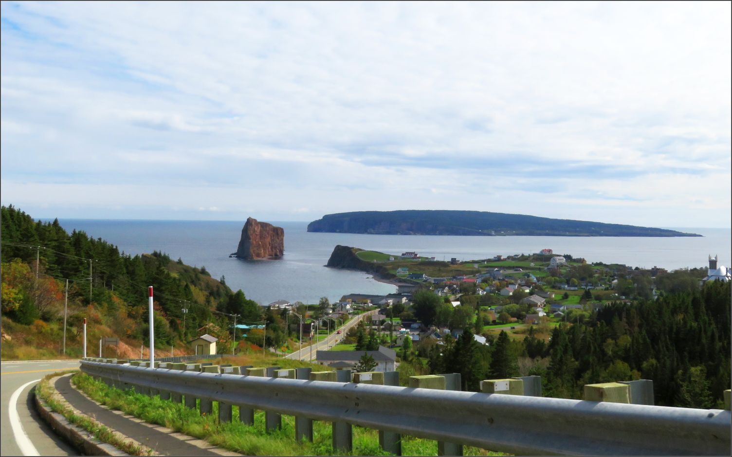
Be prepared for unexpected stops, as the winding road has so many viewpoints along the way. What makes it even more special, beside the staggering views, is that they are easily accessible. You can stop by along the route in practically every town, as the Communal stops and lookouts are now and then, every few kilometres.
There are some fantastic hiking opportunities in Forillon National Park with great chances to see wildlife, including whales, sealions, and various seabirds.
The treacherous shore not only offers some of the most beautiful sightings in this area, but it is also filled with several lighthouses. With more than 15 lighthouses along the way, Gaspesie is probably the place with the most density of them.
Read more: Falling in love with Gaspesie
We could continue the road trip along the Gulf of St Lawerence, going south to the next province New Brunswick, but we followed Rte 132 back to Mont-Joli, along Matapedia Valley.
***
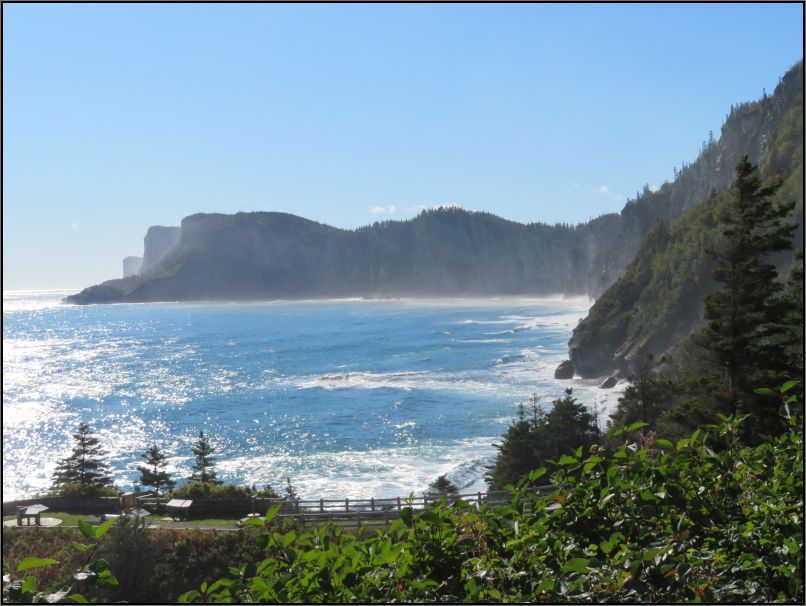
2. Cabot Trail, Nova Scotia
Nova Scotia’s Scottish Heritage is visible in many places in the province, but nowhere is it more obvious than Cape Breton. The first highway you’ll take after passing over Canso Causeway is called Cellidh Trail (Hwy #19). The Gaelic word translates in English to ‘party’ or ‘social gathering’, which feels like a welcoming name for a road.
North of Margaree, Cellidh Trail becomes Cabot Trail. The 298 km long Cabot Trail is named after Italian explorer Giovanni Caboto. His name was anglicized to John Cabot. He arrived on Canada’s shores in 1497, sailing on a mission for King Henry VII of England.
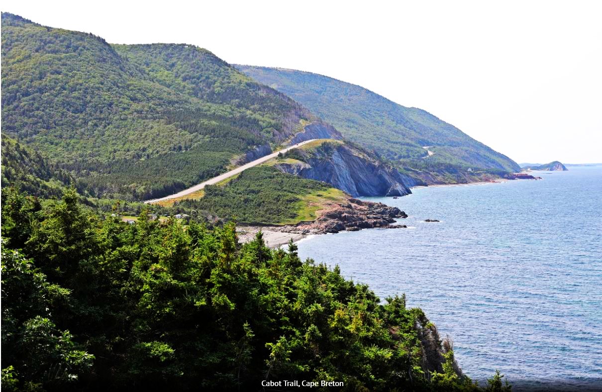
The road has a lot of steep climbs, descents and sharp corners as it follows the outline of the coast. As you drive through the park you’ll pass 24 viewpoints. A few require short hikes, but others are along the side of Cabot Trail.
The further north you drive on this famous roadway, the cliffs get larger and larger until it enters Cape Breton Highlands National Park.
Read more: Cape Breton & the Cabot Trail
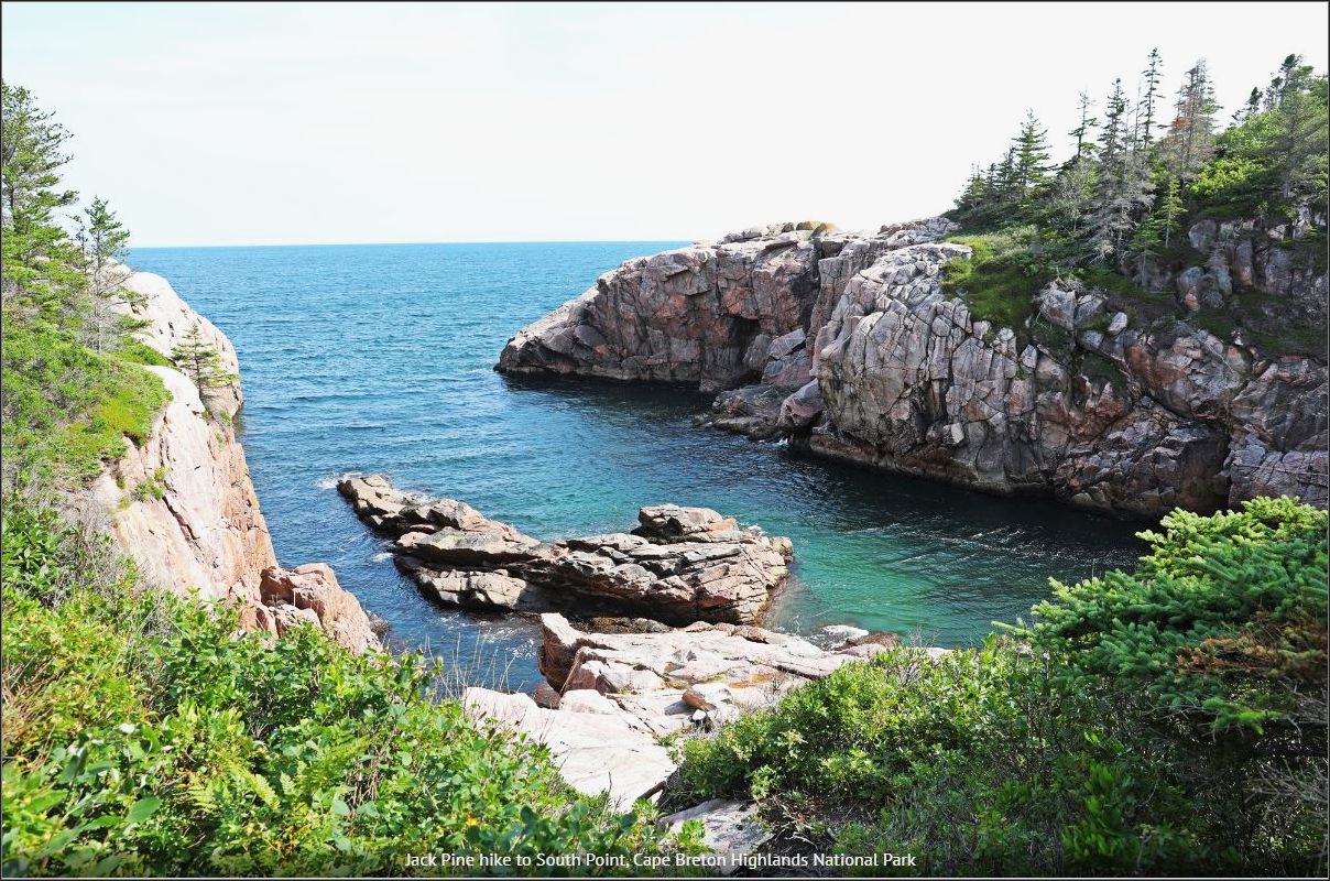
As its name suggests, there are a lot of mountains in the interior of Cape Breton Highlands National Park, and Cabot Trail cuts across the mountainous interior to reach the coast on the eastern side. There are 26 hiking trails inside the park. Most are short, day hikes.
Text and photos credit: Maggie @ Monkey’sTale.ca
***
3. The Sea to Sky Highway (Hwy 99), British Columbia
The Sea to Sky Highway (#99), one of the most scenic drives in British Columbia, runs 377 km (234 mi.) from the U.S. border to near Cache Creek. The most spectacular portion is from Vancouver to Lillooet. We have driven this route numerous times in both directions and there is always lots to see.
Driving out of Metro Vancouver, you cross the Lions Gate Bridge into West Vancouver, past Horseshoe Bay ferry terminal and along spectacular Howe Sound. Numerous pullouts allow you to take in the views, parks and attractions.
First up, the Britannia Mine Museum offers guided tours of the buildings – allow 1.5 to 3 hours for this stop. Further north, Shannon Falls Provincial Park provides hikes with views of 335 m (1,099 ft) high Shannon Falls, Stawamus Chief Mountain and the Sea to Sky Gondola.
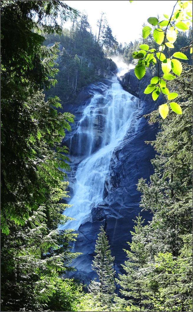
The highway continues North to Squamish, where river rafting, snowmobiling and bald eagle viewing tours can be booked. 40 minutes past Squamish is Brandywine Falls Provincial Park, where an easy hike brings you to views of 70 m (230 ft) high Brandywine Falls.
Fifteen minutes further North is the resort town of Whistler, offering both summer and winter activities. Spend a night or two here, take the gondola up for winter skiing or summer hiking, then ride the Peak-to-Peak Gondola for tremendous mountain and valley views. Zip lining and bear watching tours can also be booked.
North from Whistler, you drive through mountain scenery past Pemberton, Lillooet and on to Cache Creek. Pull over at the overlook for Lillooet Valley views or stop into the town before driving on.
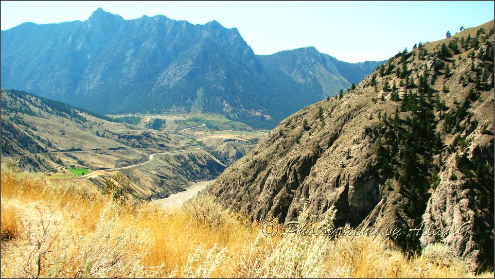
Drive time between Vancouver and Lillooet is listed as 4 hours and 9 minutes, but if you match that time, you will have missed a lot.
Text and photos credit: Allan @ PictureThis
***
4. Trans-Canada Hwy 17 along Superior Lake, Ontario
If you enjoy long road trips, natural beauty, pristine beaches, or visiting a cozy village, then, the drive around Lake Superior should be on your list. Trans-Canada Highway 17 section between Sault Ste Marie and Thunder Bay stretches over 700 km along the northern shore of Lake Superior, the largest of the Great Lakes in North America.
Although Canada, and the province of Ontario go quite far north, the region of Northern Ontario starts right here, on the shores of Lake Superior.
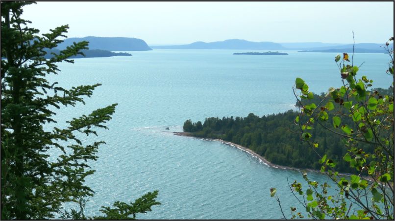
We started the drive from Sault Ste Marie, Canada (not to be confused with its American sister with same name which is across the border and St Mary’s River). Heading northwest, Highway 17 took us along Lake Superior, a great lake that it felt like it was actually an inland sea.
Wilderness, lakes, rivers, canyons, wildlife, and waterfalls, we had them all along this scenic drive. In addition to some of the best panoramic views along the way, our trip was filled with various activities. Sleeping Giant and Superior Lake Provincial parks as well as Pukaskwa National Park are the most notable park with great hiking opportunities. Agawa Rock and the pictographs are very famous landmarks, as well as the Sea Lion geological formations.
We found out that the small town of White River along the Highway is Winnie the Pooh’s birthplace, and we learned more about the fur trade life from 1816’ at Fort William, near Thunder Bay.
Have I mentioned about some of the most beautiful waterfalls in Ontario, like Mink Creek, or Kakabeka? Or about two impressive canyons: Ouimet and Eagle, the latter being home to the longest foot suspension bridge in Ontario?
Read more: Lake Superior, Ontario’s most spectacular riviera

We could continue our road trip around the lake, but we returned back on the say way, feeling there is so much more to discover.
***
5. Ingraham Trail (Hwy 4), Northwest Territories
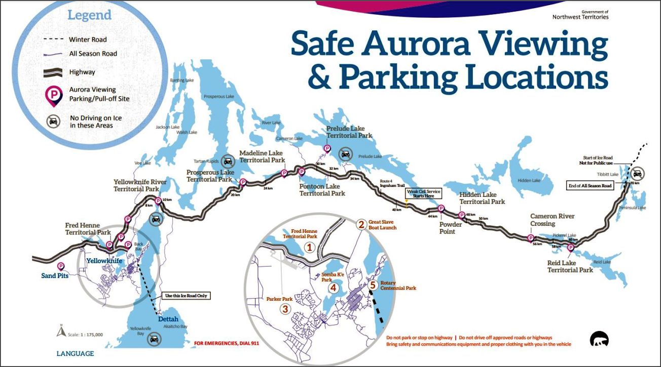
Named after a pioneer Yellowknife businessman of the 1930s-40s, the Ingraham Trail (Hwy 4) stretches from Yellowknife to Tibbitt Lake, for approximately 70 km. Dotted with lakes, campgrounds, picnic sites and boat launches, this route meanders through Precambrian landscape, from the “Age of Early Life”.
The Yellowknife River, Madeline Lake Park, Prelude Lake Park are few of the stops along the way. With an area of about 3000 hectares, the Hidden Lake Territorial Park offers some great hiking and/or paddling opportunities if you feel like spending more time in this area. Hidden Lake is said to be one of the most beautiful lakes along the Ingraham Trail on a sunny day, as the lake appears aquamarine, and fish can be spotted swimming in its crystal-clear water.
The Ingraham Trail is also the prime viewing location to experience Aurora Borealis. No wonder why, this highway is an easy access from Yellowknife, taking you outside of the city in a couple of hours to a dark area. Aurora Village, a small community where visitors can experience the magic and wonder of these dancing Northern Lights is less than half an hour driving from Yellowknife. But if you wish to experience the Northern Lights on your own, you can always use the Ingraham Trail, following the safe viewing and parking locations.
Named after the Roman goddess of the dawn, Aurora Borealis is a unique experience. It is said it is visible up to 240 days a year in the capital of Northwest Territories.
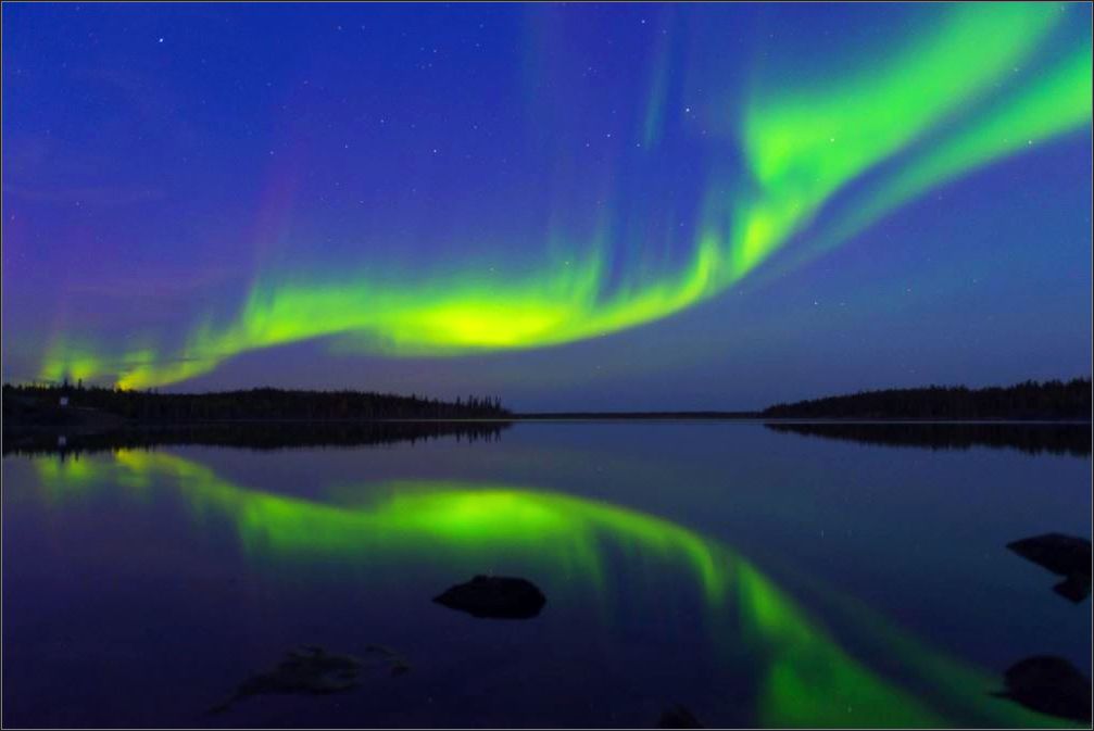
I can only hope I’ll get a chance to make it to Yellowknife one of these 240 days, someday😊
***
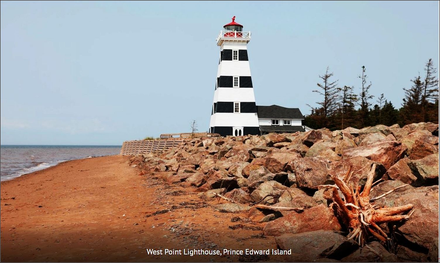
6. The lighthouse route, Prince Edward Island
Standing on the edge of steep red cliffs, the lighthouses on Prince Edward Island have some of the most picturesque settings. With 700 km of coastline, there are many of these iconic scenes on this pretty island province. From the stripped West Point Lighthouse, to the oldest on Point Prim, you will not be disappointed in your quest to find the perfect lighthouse.
Our Great Canadian Roadtrip brought us to Prince Edward Island (PEI) where we wanted to see as many lighthouses as possible. Below are our favourites and a suggested route so you can visit them on your next trip to PEI. If you take Confederation Bridge to reach the island, the first lighthouse you should visit is on the south west coast. The black and white stripes of West Point Lighthouse provide contrast to the bright red beach at its base.
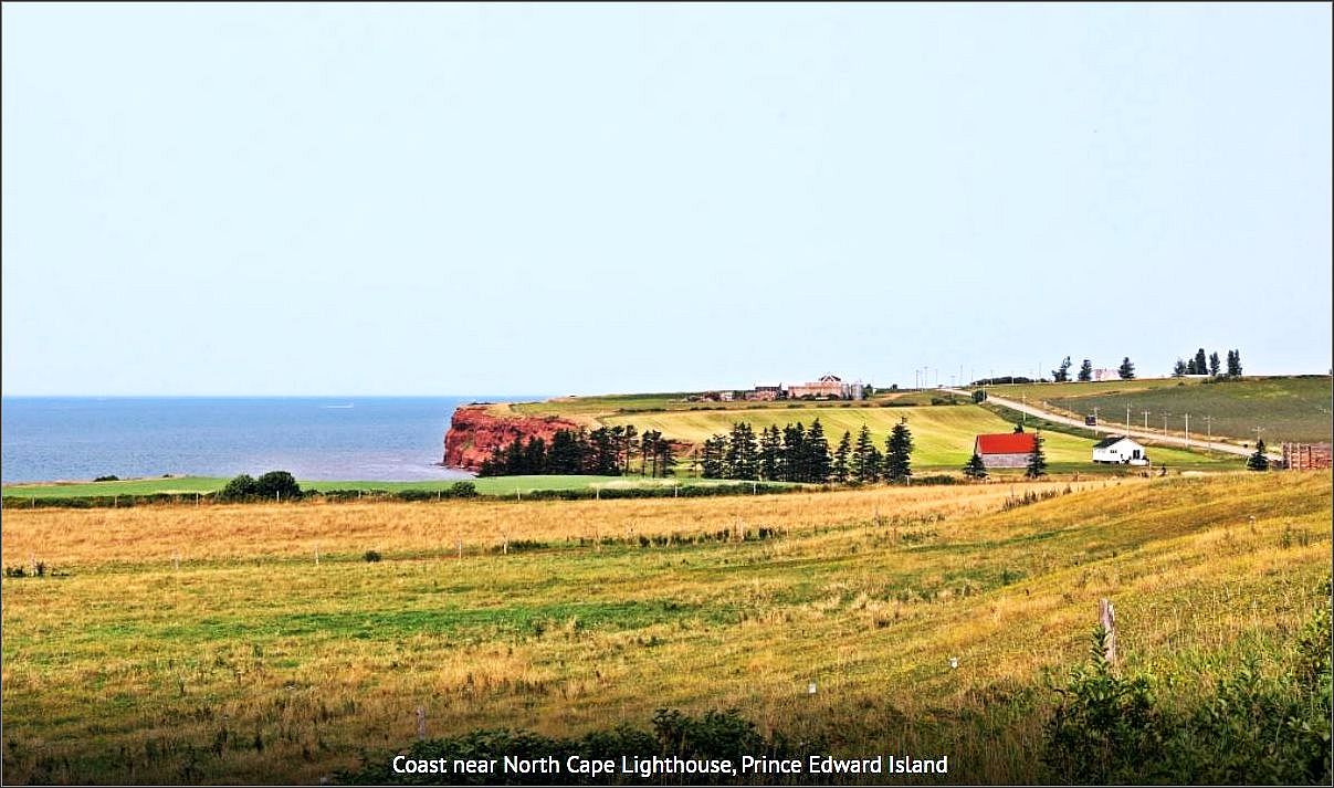
After West Point, take the coastal road to the most northerly point on PEI to reach North Cape Lighthouse. The road travels between fishing villages where lobster traps are piled high during the off-season. On the other side of the road the landscape is dotted with farm houses and potato fields. The white and red North Cape Lighthouse sits above a rugged red coast.
Read more: Picturesque lighthouses on Price Edward Island
The drive from North Cape to Cape Tryon will take you near the town of Summerside, and then to Cape Tryon Lighthouse. The white lighthouse stands proudly above bright red cliffs and the rough waters of the Gulf of St. Lawrence. The setting looks like a picture-postcard. It is so pretty that we saw a couple getting their engagement pictures taken there.
From Cape Tryon follow the northern coastal route to reach the east coast. The drive takes you through cute towns like St Margaret’s and St. Peter’s. At the most eastern point on PEI is the octagonal shaped East Point Lighthouse, nicknamed “Canada’s Confederation Lighthouse” because it was the only lighthouse in Canada that was built in the year of confederation, 1867.
End your lighthouse tour at Point Prim Lighthouse. Point Prim is a long narrow point and the lighthouse marks the southeastern entrance to Hillsborough Bay and Charlottetown Harbour. Surrounded by a green park, Point Prim is the oldest lighthouse in Prince Edward Island. The circular lighthouse was made out of brick and covered in wood shingles, and it was built in 1845.
Text and photos credit: Maggie @ Monkey’sTale.ca
***
7. Hwy 60 Corridor of Algonquin Park, Ontario
Highway 60 runs from Trans-Canada Hwy 17 in Renfrew, to Hwy 11 in Huntsville, but the most scenic section is the 56 km corridor that passes through the southern part of Algonquin Provincial Park.
There are a couple of museums along the way. The Logging Museum, just after passing the East Gate entrance is an outdoor museum, offering several exhibits along a trail in the neighbouring forest.
Shortly after, the visitor centre is another place to learn bits of history, and lots of explanations and exhibits about the wildlife in this area. We make sure we don’t miss the observation platform from the back of the building every time we stop by, as the valley of the adjacent lakes and forests offer views of several habitats, along with a breathtaking panorama.
Read more: Fall walks, Algonquin Park in October
There are 15 trails in total in Algonquin park (except the backcountry ones) with length varying from 1 km to 10.8 km.
With plenty of campgrounds and several lakes within easy access from Hwy, Algonquin Park is a great destination. The park is opened year-round, although some trails may be closed during the winter season. The park is especially popular during the fall season, in order to enjoy the fall foliage, in late September – early October.
A day pass is required to enter the park, which can be obtained at any of the gates, or online.
***
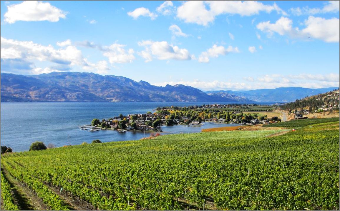
8. Okanagan valley, British Columbia
As we were getting close to Okanagan Valley, we noticed a totally different scenery from what we were used to driving on the west coast of British Columbia (and Canada).
The gridlock we encountered while trying to cross the bridge over Okanagan Lake gave us a hint of this new region lay out, with Kelowna on the eastern shore of the lake, and a huge expanse all around, nestled between the rocky mountains. The Okanagan Valley is roughly 200 km long and 20 km wide, and is protected by Columbia and Cascade Mountain ranges. Towns like Peachland, or Summerland make you wonder what they could be hiding behind such cute names, along with many other small communities tucked into the rolling hills of these imposing mountains.
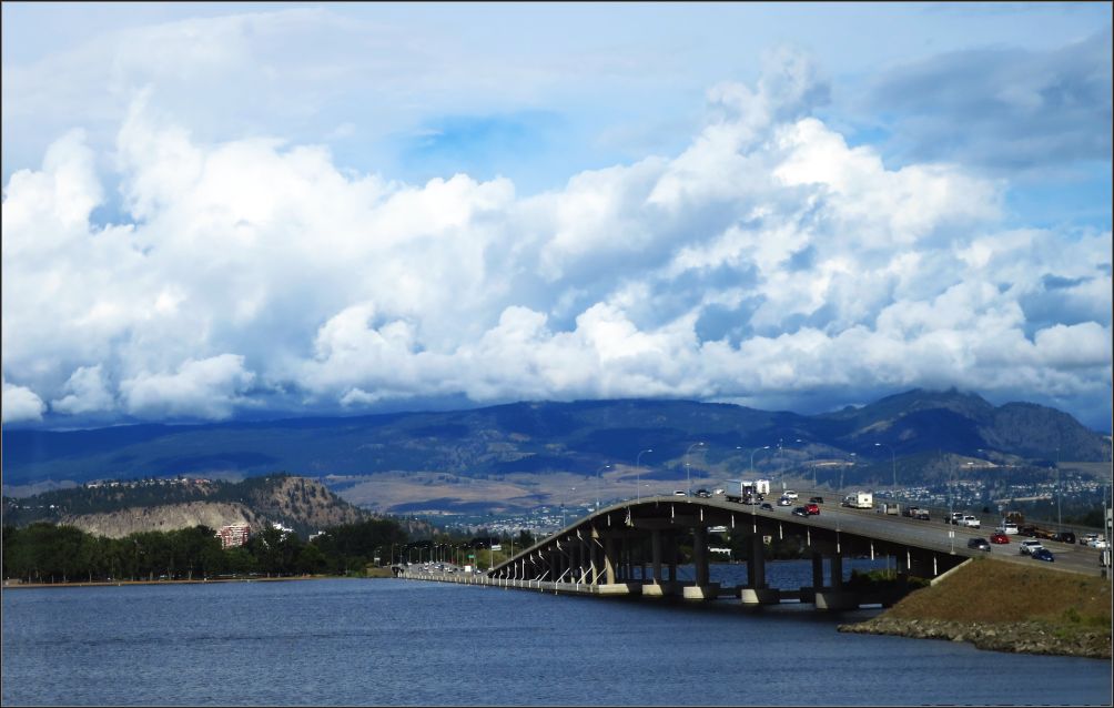
The city of Kelowna, located halfway between Vancouver in British Columbia and Banff National Park in Alberta, is the heart of the Okanagan Valley (or Okanagan Country as it is also known). One of the largest producers of wine in Canada, the region is famous for its sunny and temperate climate, and especially for its orchards and vineyards. Two Wine Festivals are held every year in Kelowna, in the spring and fall, as well as several other events throughout the year.
Penticton, another notable city, is located on the southern shore of Okanagan Lake, and has more than 80 wineries, 2 cideries, and 3 distilleries alone. Beaches and water fun are part of the summer culture here, culminating in August, when the Peach Festival maintains the South Okanagan Valley tradition since 1947, celebrating the region’s peach harvest.
***
9. Icefields Parkway (Hwy 93), Alberta
Highway 93, the Icefields Parkway, runs 268 km (167 miles) down mountain valleys between Highway 16, South of Jasper town and the British Columbia boundary at Vermilion Pass. It has some of the most beautiful scenery in the Canadian Rockies. A valid Parks Canada pass is required to drive through Jasper and Banff National Parks. Maximum speed is 90 km/h (55 mph), but lower in wildlife corridors and near tourist attractions. Make sure your gas tank is full, as the fuel stops are few and far between.
Travelling South from Jasper, there are numerous stops of interest along the way, such as Jasper Tramway which rises to a height of 2,263 metres (7,425 ft), providing panoramic views. Or Athabasca Falls with a drop of 24 m (79 ft), and Sunwapta Falls of 8.5 metres (61 ft).
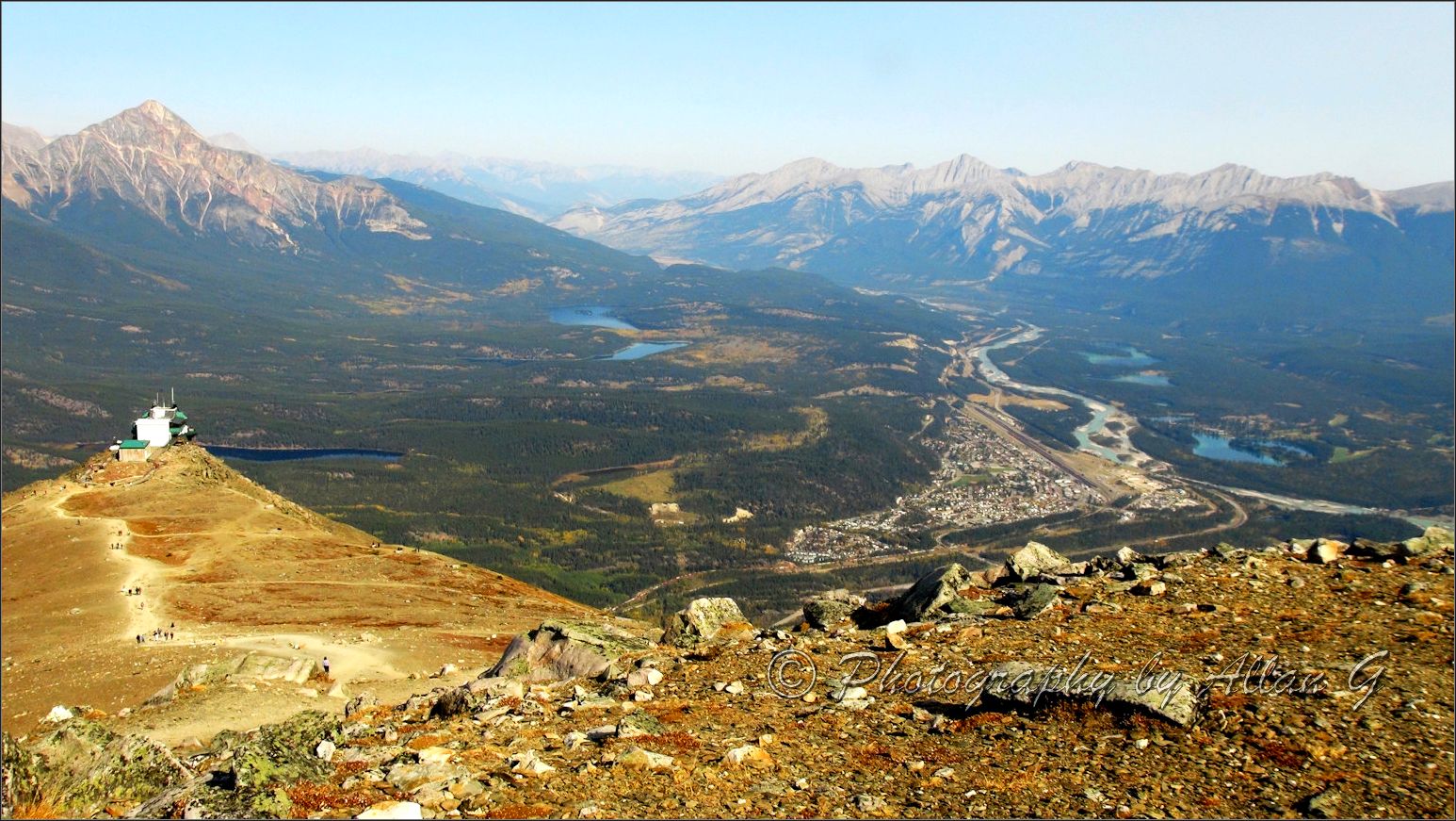
As you drive further South, you are surrounded by soaring peaks, beautiful rivers and numerous hiking opportunities. Roadside pullouts allow for great views, including Athabasca River, or the Stuttfield Glacier.
Just before you reach the Icefields, attractions come fast and furious: Tangle Falls with 4 drops, and is 48 meters (157 1/2 feet) tall, Jasper Glacier Skywalk with a cantilevered glass floor over a hanging valley.
The Icefields Center allows you to book tours on the Skywalk and the Columbia Icefield Adventure by Snow Coach. Not far past the Icefields Centre, you cross into Banff National Park, with its own scenic stops.
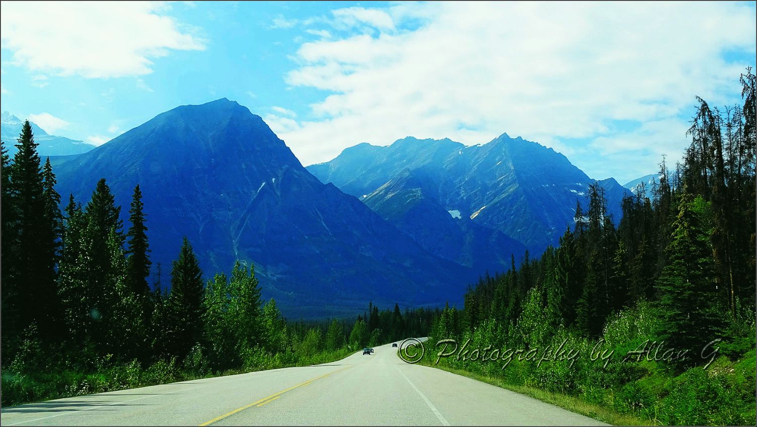
A good summer hike is located at Parker Ridge. If you come before June, bring skis or snowshoes.
Big Bend provides some pretty dramatic scenery. Before long, you start passing lakes of azure blue, like Peyto Lake. Be aware that during peak summer season, you require a bus reservation to view Morraine Lake and Lake Louise.
The Icefields Parkway is our favourite Alberta drive.
Text and photos credit: Allan @ PictureThis
Read more: Rocky Mountains, Icefields Parkway and its wonders
***
10. Discovery Trail, Newfoundland
With a length of approximatively 425 km, Discovery Trail is essentially the road that circles Bonavista Peninsula, with three road entrances: Routes 230 and 230A in Clarenville, and Route 233 in Port Brandford.
With a rugged coastline due to the collision of tectonic plates that shaped Newfoundland geology, the winding coast of Bonavista Peninsula offers some of the best scenery on the island, if not in all Canada.
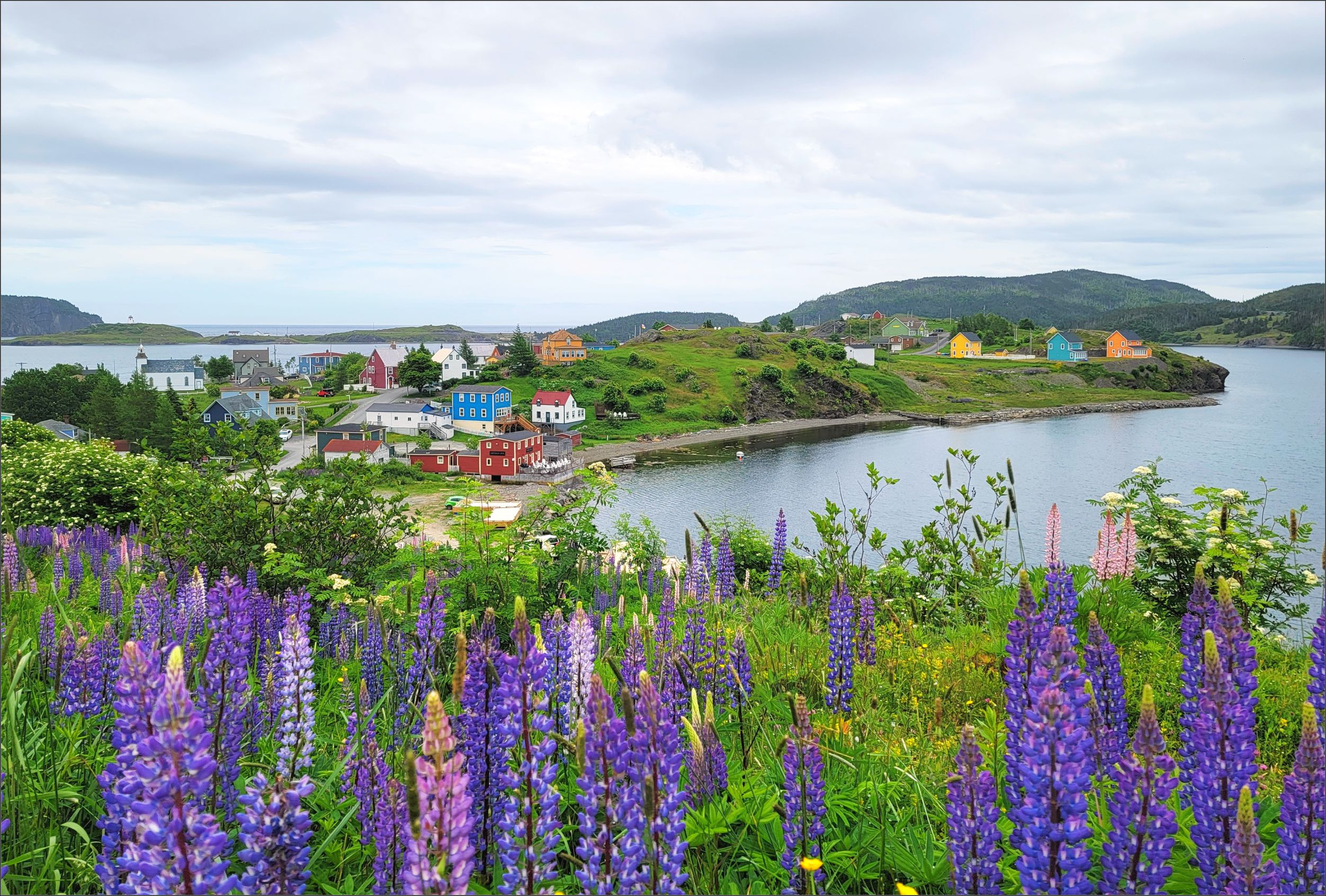
If you go to Newfoundland to see new scenery, to learn about the places where the first Europeans arrived in North America, to enjoy good food, or some great trails, then this is the place where you can have them all.
As the name suggests, Discovery Trail is a road filled with attractions and landmarks waiting to be discovered. Lighthouses such as those from King’s Cove and Cape Bonavista still provide guidance to the sailors from these waters, and towns like Elliston, Bonavista and Trinity provide guidance to the visitors throughout the centuries of history of these lands. We loved watching the puffins in a few places, and hiking the Skerwink trail, one of the most famous trails along the eastern coast.
Surrounded by the ocean, the entire peninsula, offers quite a diverse landscape. Wind, water and time have shaped in a unique manner many parts of the peninsula, which is why it has so many natural scenic attractions like sea stacks and sea arches.
Read more: The best things to see and do along Discovery Trail
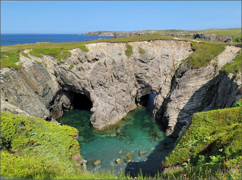
Dungeon Provincial Park is just six-minute drive from Bonavista, and offers fantastic views of a collapsed sea cave with natural arches carved by the sea. Another sea arch is in the opposite direction from Bonavista, in the middle of Tickle Cove. These two were our favourite ones.
Many thanks to Maggie at Monkey’sTale.ca, and Allan at PictureThis for their special contribution.
Happy travels, wherever you are!

.jpg)
realy intersting! Thank you!
LikeLiked by 1 person
Thank you for stopping by!
LikeLike
Great post; sorry I ran out of time to contribute. Fyi, Canada is still second largest by land mass (excluding water) if Antarctica is excluded. https://en.wikipedia.org/wiki/List_of_countries_and_dependencies_by_area
LikeLiked by 1 person
Thank you Lynette! Don’t worry, hope you’re having an amazing trip! We are leaving in few days too🙂
Indeed, Antarctica is always excluded from these charts. Canada is the 4th by land, after Russia, China and US.. still in good shape😀
Happy Tuesday!
LikeLiked by 1 person
Actually, I read the chart wrong since it was numbered as 2 on the left, but that refers to total area. I stand corrected.
LikeLiked by 1 person
xoxo
LikeLiked by 1 person
Have to say, Christie, I have been on most of these roads over the years traveling by bicycle, car and van. You are absolutely right. They are beautiful.
LikeLiked by 1 person
I think I remember you did a 10K km by bike at some point. Really impressive, Curt! Life is beautiful🙂
LikeLike
Laughing, yeah 10,000 miles is a bit more than 10 k. My Canadian portion included Nova Scotia, New Brunswick, and more remote sections of Quebec and Ontario coming out at Thunder Bay. It was an incredible trip. A few years ago, Peggy and I redrove my route out of California traveling a souther route through the US, up to Main, across Canada as described above and the back to California following a northern route.
LikeLiked by 1 person
Yeah, it was miles, correct🙂
Enjoy the summer!! xx
LikeLiked by 1 person
This is such a great idea Christie. Thanks for including us in your post. The only one I haven’t been to is NWT. Maggie
LikeLiked by 1 person
Me too🙂 Thank you again for your contribution! xx
LikeLike
It looks stunning, top to bottom. It’s not a place to live if you’re not a driver, is it, Christie? I’ll have to be content looking over your shoulder.
LikeLiked by 1 person
True, the distances are great, but I love a nice road trip now and then. Actually, you really have an awesome feeling of freedom once you get out from the city crowdedness😜
But you always have the option to fly to a certain point, and then rent a car locally, this is how we did most of the places🙂
Happy Wednesday, xx
LikeLiked by 1 person
Nice to see it all come together Christie. I am pleased to say I have driven every one of these drives. I did not go all the way to Tibbitt Lake on the Ingraham Trail, but enjoyed what I did see. Thanks for showing Canada’s varied beauty. Happy Wednesday. Allan
LikeLiked by 1 person
Thank you Allan for your contribution, you have such extensive experience on the Canadian roads.
I think Canada is one of the most beautiful countries in the world❤️🙂
LikeLiked by 1 person
This is an awesome list! I’ve driven just two of these – Icefields Parkway and Cabot Trail – and a small section of the PEI loop, so I guess I’ll be adding the remaining seven and a half of them to my list. Especially the NT one! That looks amazing!
LikeLiked by 1 person
Sorry, didn’t realize I wasn’t logged in for that reply!
LikeLiked by 1 person
That’s a great start! I’m sure there are some other beautiful drives, as the country is so large. Glad I could bring some inspiration to you! xx
LikeLike
Wow not only do those drives sound absolutely amazing but those stats at the beginning are just mind blowing. I may have to do the coast to coast marathon drive one day with absolutely no intention of doing it in under 84 hours!
LikeLiked by 1 person
There is absolutely no reason to race across such a beautiful country, you will definitely get distracted along the way😍
LikeLiked by 1 person
I am hugely impressed by the comprehensive list you compiled of Canada’s most famous drives. It was a daunting read because of the mammoth distances covered but enthralling to know what’s ‘out there’ for the adventurous driver! Being Canadian, I’ve traveled many of those roads but there are far more still to discover. Being a facts and figure person, I also loved all the trivia at the beginning of the article. Thanks for an inspiring read.
LikeLiked by 1 person
Indeed, the distances are great, but also the scenery, and I’m sure there is still more to discover. I actually had a couple of more drives in mind, but I thought it’s going to be too much😍
Thank you for your kind note! Cheers,
LikeLiked by 1 person
Thanks for taking us on all these trips. Some we know from the time when we lived in Montreal others were new to us. Your post reminded us of a happy 6 years in beautiful Canada.
Wishing you a wonderful weekend
The Fab Four of Cley
🙂 🙂 🙂 🙂
LikeLiked by 1 person
There is so much to see, and so little time LOL
Glad to bring you back nice memories🙂
Have a wonderful weekend you too!!
LikeLiked by 1 person
Canada is not only a big country, it probably also has some of the most beautiful natural scenes in the world! You are spoilt for choice with a beautiful coastline, but also the most beautiful mountain ranges! It’s so amazing that it’s impossible to choose a favourite route … but I have to say, I really like that lovely photo of Trinity. And while we really like hiking, I don’t think we’ll tackle The Great Trail in its total length — that may take a lifetime!
LikeLiked by 1 person
The Great Trail is a bit too much I think, even for the avid hikers🙂 But glad there are some incredible options for all tastes!
As you said. it is impossible to choose a favourite route, I had a hard time to order them out🙂
Have a beautiful weekend!! xx
LikeLike
The Great Trail is a bit too much I think, even for the avid hikers🙂 But glad there are some incredible options for all tastes!
As you said. it is impossible to choose a favourite route, I had a hard time to order them out🙂
Have a beautiful weekend!! xx
LikeLike
We’ve done just over half of these scenic drives. The only other one I’d add to this list is the stretch of the Alaska Highway that runs through Canada, mostly through the Yukon.
LikeLiked by 1 person
I know!! I would have liked to have your contribution here, as I know you have been recently on that section, but I also know the little M. keeps you busy🙂
Have a lovely weekend! xx
LikeLiked by 1 person
That she does! She’s starting to roll, which means we have to keep a closer eye on her! Enjoy the rest of the long weekend as well. I’m just in the middle of getting my garden started.
LikeLiked by 1 person
Great information and up to date…no need for a tour book.
LikeLiked by 2 people
Thank you😍
LikeLike
I live in Vancouver and drive up to Whistler quite often. The view never gets old! It is simply breathtking. I’ve driven to the Okanagan and a bit in Nova Scotia. I’m saving more driving in Canada for when i’m too old to fly to Italy! Ciao, Cristina
LikeLiked by 1 person
There is so much more to explore across the country🙂
Happy Canada Day!!
LikeLiked by 1 person
This is such a fantastic list! Canada is exceptional and a fantastic place to go for a road trip whether you are exploring the stunning coastlines of eastern Canada or wish to cruise along Icefields Parkway. I have to say that my Canada road trip wish list is longer than my arm as I’ve also included Vancouver Island’s Pacific Rim Highway which runs from Port Alberni to Tofino and Alberta’s Dinosaur Trail. Thanks for sharing, and have a good day 🙂 Aiva xx
LikeLiked by 1 person
Oh, yes, that section is on my list too😍 And there are some great hiking opportunities in the park too! I barely scratched the surface with this list, there are so many other incredible places to visit!
Have a wonderful weekend! xx
LikeLiked by 1 person
🥰🥰🥰
LikeLiked by 1 person
Wow, I hope to remember this post and drive one of these scenic routes one day.
LikeLiked by 1 person
Thank you!!🥰🥰
LikeLiked by 1 person