
“Long ago, Nenabozhoo was down south taunting some Mohawks. The angered Mohawks chased him north up the Zaagiing (Bruce) Peninsula. Luckily, his grandma awaited him on the shore with a canoe. They paddled hard across the water to Mnidoo Mnis (Manitoulin Island), the Mohawks close behind. Once on the Island, Nenabozhoo kept running, carrying his grandma on his back. Too tired and scratched up, he threw her off, promising to return for her. She landed in the middle of Mindimoowenh Zaag’igan (Lake Mindemoya), where she still rests today as Treasure Island. Nenabozhoo then ran, through M’Chigeeng and arrived here where you stand. He transformed into a giant and began readying his spearhead and handle. But as the Mohawks caught up to him, he suddenly lost his helve. He dropped his disassembled spear and ran off. Nenabozhoo’s giant spearhead and handle remain here to this day. The lower, smaller bluff is the spearhead, and the higher, longer bluff forms the spear handle”
~ based on a story told by late Johnny Debassige of M’Chigeeng.
Considered The Heart and Spirit of the Great Lakes of Canada by the Native Anishinaabe people, Manitoulin Island is a sacred land, home of many legends, and stories.
Known as the largest freshwater island in the world, an island with over a hundred inland lakes itself, Manitoulin Island is a very popular destination for Ontarians. We have been familiar with it since 2017, when we took a road trip around Lake Huron, one of the five Great Lakes of North America. This is our third visit to the island, coming specifically to hike the Cup and Saucer Trail.

Not sure if it’s the legends that draw the visitors to this part of the world, the hike itself, or the views, but I was quite surprised to see two large parking lots full of cars once we arrived in the park.
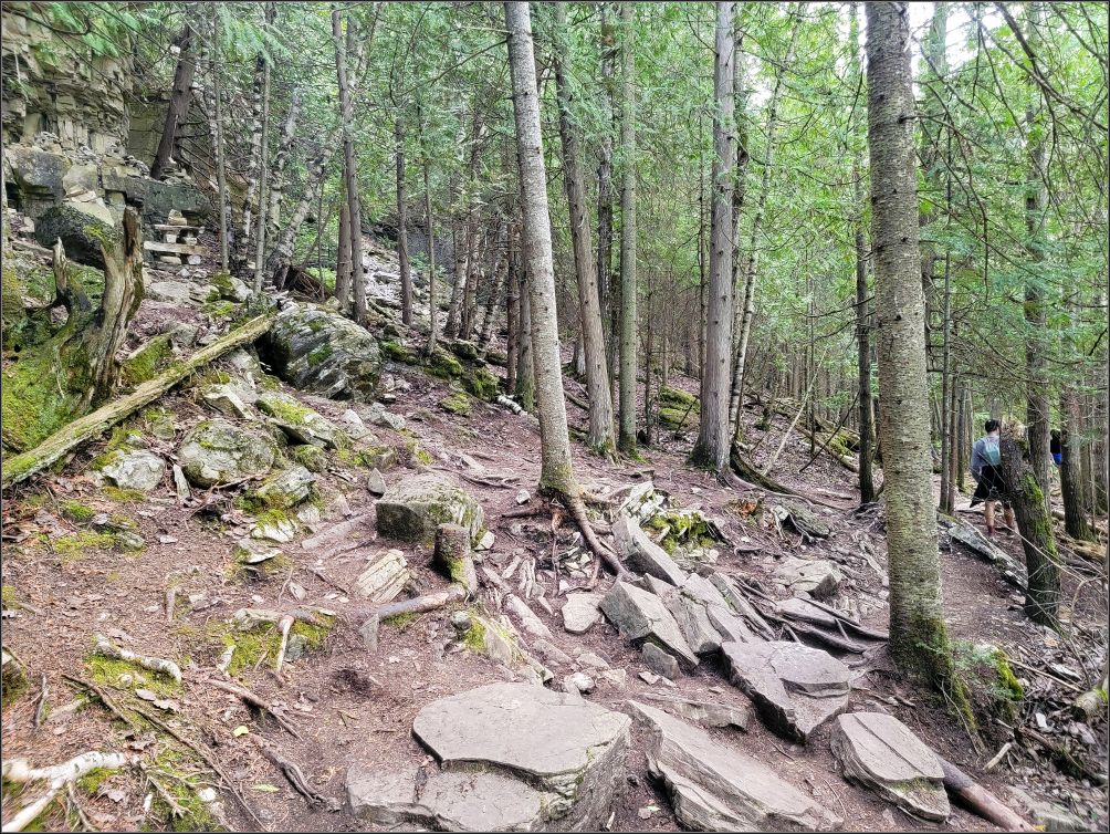
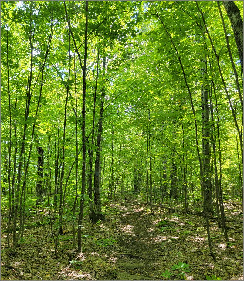
Leaving the parking lot, we headed gently upwards through the woodland. Nothing uncommon, until the path turned right, and suddenly the trail got lost through a rocky field. We came across with Niagara Escarpment again, a surprise as we didn’t know we could find this escarpment across the Georgian Bay.
Read more: Manitoulin Island by Chi-Cheemaun
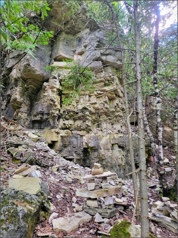
Part of the UNESCO heritage, the Niagara Escarpment stretches for more than 1,000 km from New York state through Ontario (Canada), Michigan, Wisconsin and Illinois, back in the states, in the shape of an upside-down “U”. The escarpment is the most prominent of several escarpments formed in the bedrock of the Great Lakes, and it’s especially famous for the cliff where Niagara River plunges into Niagara Falls.
The gentle uphill start of the trail quickly changed to a more irregular path, with lots of rocks and tree roots along the way. But we were already used to that, when we hiked the Lion’s Head trail on the previous day.
We passed a few groups, only to line up with other people, in front of a big outcrop. There was no other way around, as the staircase we had to climb was for people coming from both directions.
Read more: Best things to see and do in Manitoulin Island
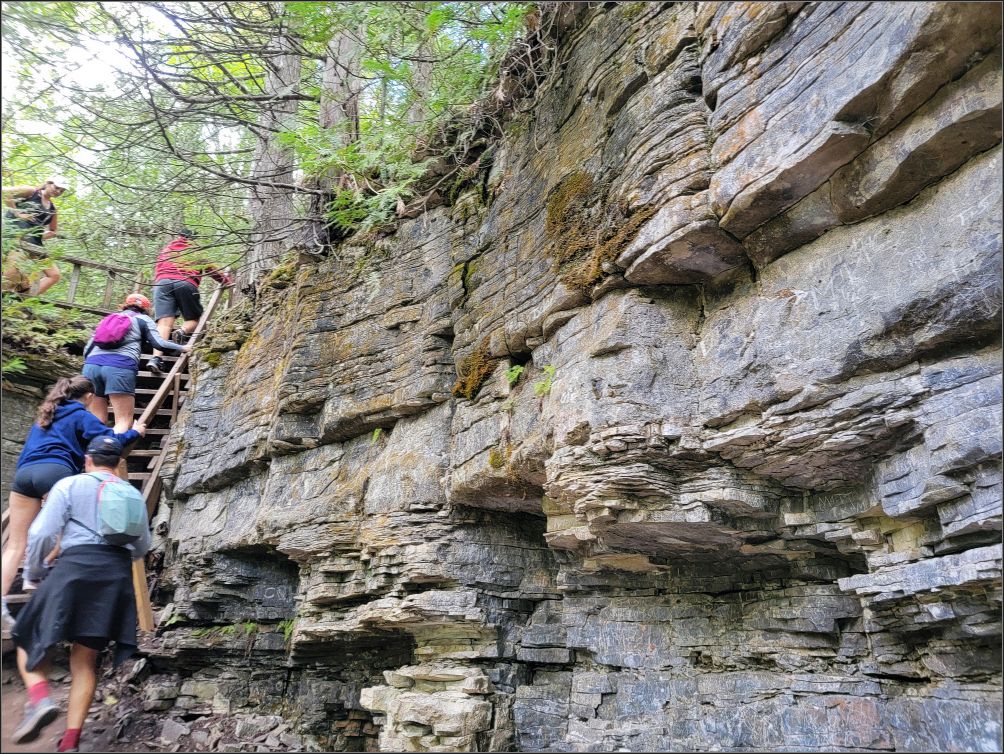
With a hot and humid summer of 2024, any forest we’ve visited recently has been like a heaven for moss and ferns. The slope gradually increases, and the higher we go, the more rocks of various sizes appeared on our way. Groups of people come and go, we had to constantly pass each other, as the trail isn’t too wide in most places.
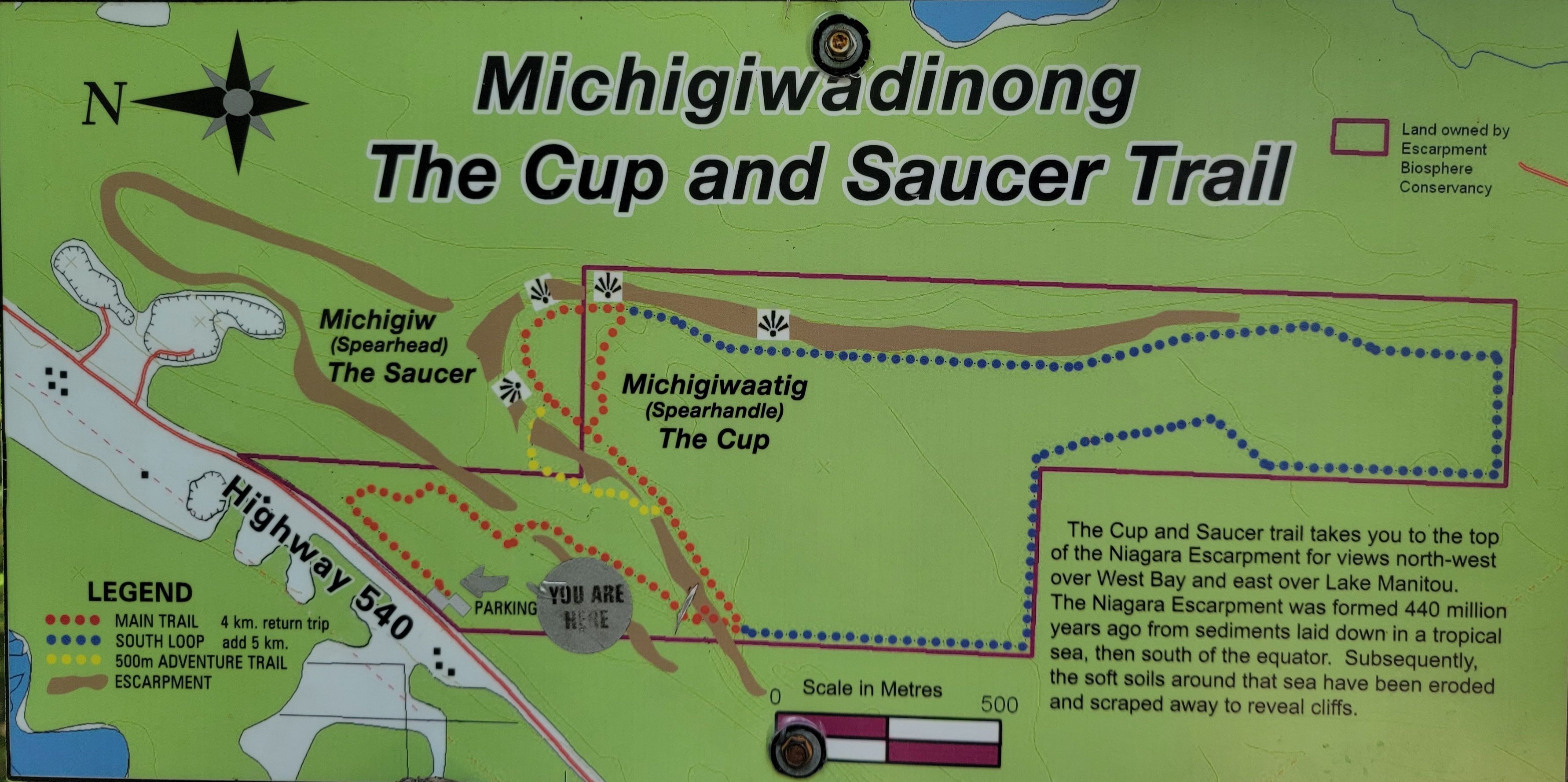
We soon intersected with the 500 m side trail called “The Adventure Trail” and we decided we are not that adventurous today. We wanted to do the South loop instead, which would add up a 5 km, accordingly with the map located at the trailhead.
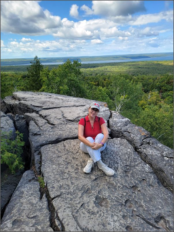
We started the hike clockwise, and soon we found the first lookout, a cracked cliff jutting out of the forest. I was hesitant to approach the edge at first, as this is not the safest place I’ve come across to, for sure. The green forest below and Lake Manitou in the distance make for a great backdrop, and we stopped a bit for a respite.
Read more: Fun at the beach, Manitoulin Island – Providence Bay
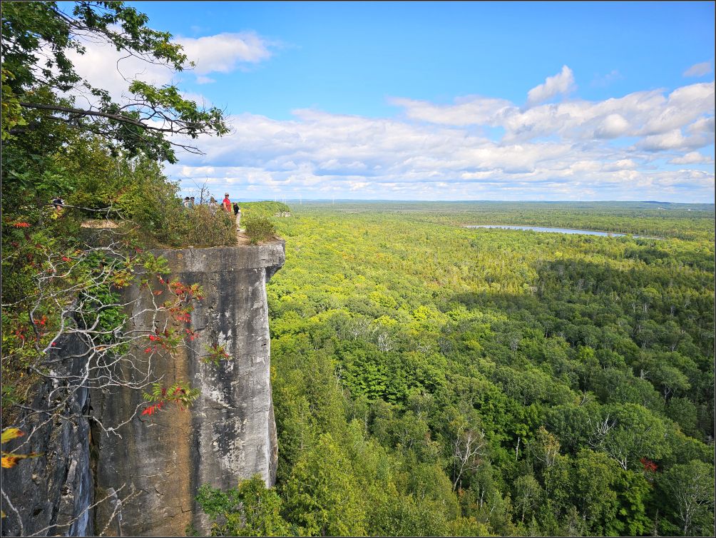
With cliffs over 70 meters high, The Cup and Saucer Nature Reserve offers over 300 acres of pristine land, and few hiking trails. The cliffs are called “Cup and Saucer” because the higher Cup is perched on the lower Saucer formation. 440 million years of erosion created them, and today we’re here to walk over them. They are Silurian deposits and quite famous both for their appearance, and for the beautiful vistas of the surrounding valley.
After another short walk, we reached the main lookout, where we found several people flocking precariously to the very edge of the unprotected cliff. The side of the adjacent cliffs are very imposing, with scars older than what we would like to imagine. I tried to stay away myself, but the edge was like a magnet, making me take small steps towards it. I didn’t want to look down, so I could pretend I wasn’t afraid.
My husband saw another adjacent cliff top sticking out, and told me to stay where I was so he could take a picture. But when I saw him so close to the brink of the other cliff, I suddenly panicked, feeling myself dizzy, and everyone looked at me when I started yelling at him to go. I ran away, ashamed of my fear of heights. It’s always been there, although occasionally I like to overcome that feeling.
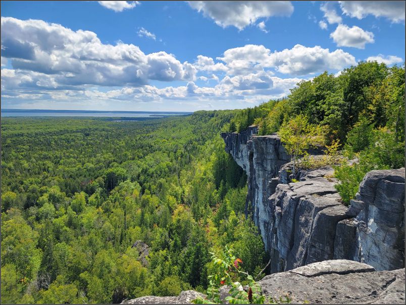
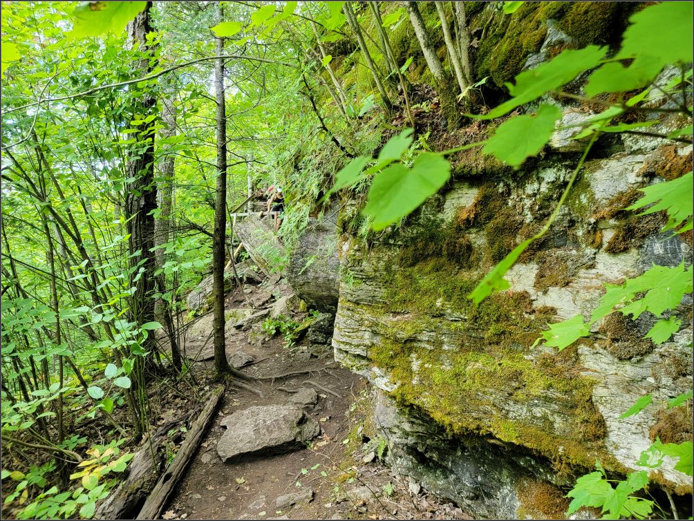
The path generally sticks to the top of the escarpment, and I am so glad once we leave the noisy crowd behind, and find few interesting rock formations along the way where we can rest and enjoy the view peacefully.
Read more: Manitoulin Island, In search of lost lighthouses
After this generous break, the trail took us through the rich canopy of a young mixed forest of the reserve. The path became more leveled, letting us pick up our steady pace. We met very few people along the way, which made for a nice walk in the woods, letting us absorb all the energy for ourselves.
Getting back to the parking lot was via the main trail which we intersected at some point, and after a small donation using the barcode at the trailhead, we headed to the site we selected for a quiet evening.
Tip(s) of the day:
- Wear proper footwear, most of main trail is rugged;
- The main trail is 4 km long, including the return and takes you to the Cup and Saucer lookout point. If you wish to do the South Loop as well, you need to add up 5 more km. It took us 3 hours in total, breaks included;
- The trail is very well worn out, there is no way you can get lost. There is only a little confusion when the South loop links back with the Main one, but eventually we got it right;
- This trail is not recommended for small and/or unsupervised children since all cliffs are unprotected and numerous cracks in the rocks along them;
- The Nature Reserve and the trail are located 18 km West of Little Current at the junction of Hwy. 540 and Bidwell Rd. Or 50 km north of South Baymouth if you arrive on the island by the ferry;
- There are 2 large parking lots, free of charge. There is a barcode right at the trailhead, that directs you to Escarpment.ca if you wish to donate.
~ visited on Sep 1, 2024

Very informative post about this trail. Thanks, Christie.
LikeLiked by 1 person
Thank you Lynette! Happy Thursday🥰
LikeLiked by 1 person
Thanks for the story Christie. Always nice to hear how the legends get started. A beautiful part of Canada we have not yet made it to. Have a good evening. Allan
LikeLiked by 1 person
A beautiful part of Ontario indeed, with pristine lands and sunny skies. Have a great afternoon you too!
LikeLike
I love the legend that goes with the island. It was pouring rain when we thought of visiting Manitoulin Island a couple of summers ago. The rain deterred us but I want tooheartbroken because I had read that there are a lot of snakes on the island and I didn’twant to go anyway. That’s my phobia. 😊 Maggie
LikeLiked by 1 person
Hmm.. I do not think there are more snakes on the island than any other place in Ontario. Actually, the most venomous snake in Ontario, Massasauga is found primarily along the eastern side of Georgian Bay and on the Bruce Peninsula. When you think that we hiked quite a bit along Bruce Peninsula.. lol.. but we usually stay on the trail, careful not to step aside. I’m not their fan either😀
LikeLiked by 1 person
I love Manitoulin Island and this is such a great hike. Sorry to hear that the trail was crowded, but it sounds nice that you got to enjoy some quiet moments as well.
LikeLiked by 1 person
It was a beautiful long weekend, everybody way out😍
Have a wonderful Thanksgiving long weekend, Linda!
xx
LikeLiked by 1 person
It looked like a perfect day… a shame there were so many people. I would have had the same problem with heights on those cliffs.
LikeLiked by 1 person
No wonder why there were so many people on the trail, as that particular long weekend was so beautiful!
Thank you for your lovely comments, and have a great day! xx
LikeLiked by 1 person
I don’t think I’d have the nerve to do this, Christie, though the views are fabulous. Those drops are steep and the trail looks quite close to the edge. I loved following you though.
LikeLiked by 1 person
These trails are quite unique to say so, as the Canadians are normally overprotective when talking about safety. But we stayed away from the edge, so everything was good😊
LikeLiked by 1 person
looks like a challenging hike to some extent but beautiful surrounds
LikeLiked by 1 person
Indeed, we were rewarded with an amazing view at the main outlook, and luckily we found a quieter spot to relax and enjoy the view. Thanks for popping by!
LikeLike